Day Valley elevation
Day Valley (California, Santa Cruz County), United States elevation is 415 meters and Day Valley elevation in feet is 1362 ft above sea level [src 1]. Day Valley is a populated place (feature code) with elevation that is 136 meters (446 ft) bigger than average city elevation in United States.
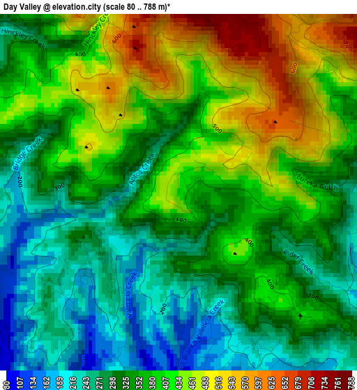
Below is the Elevation map of Day Valley, which displays elevation range with different colors. Scale of the first map is from 80 to 788 m (262 to 2585 ft) with average elevation of 361.1 meters (=1185 ft) [note 1]
These maps also provides idea of topography and contour of this city, they are displayed at different zoom levels. More info about maps, scale and edge coordinates you can find below images.
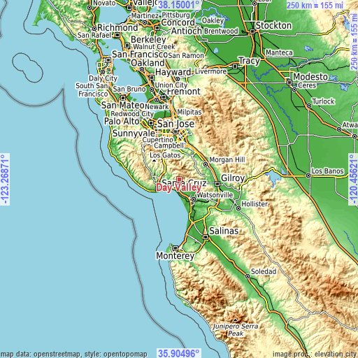
| \ | Map #1 | Topo.Map |
| Scale [m] | 80..788 m | × |
| Scale [ft] | 262..2585 ft | × |
| Average | 361.1 m = 1185 ft | × |
| Width | 7.8 km = 4.8 mi | 249.6 km = 155.1 mi |
| Height | 7.8 km = 4.8 mi | 249.6 km = 155.1 mi |
| ↑Max Latitude | 37.070852° | 38.15001° |
| Latitude at center | 37.03578° | 37.03578° |
| ↓Min Latitude | 37.000692° | 35.90496° |
| ← Min Longitude | -121.906405° | -123.26871° |
| Longitude center | -121.86246° | -121.86246° |
| →Max Longitude | -121.818515° | -120.45621° |
Nearby cities:
Cities around Day Valley sort by population:
• Live Oak elevation 36 m
12 km,  241°
241°
• Scotts Valley 172 m
13.6 km,  277°
277°
• Capitola 7 m
10.5 km,  230°
230°
• Soquel 11 m
9.9 km, 237°
• Rio Del Mar 49 m
8.2 km,  204°
204°
• Aptos 34 m
7.3 km,  206°
206°
• Opal Cliffs 12 m
12.3 km, 227°
• Amesti 48 m
10.9 km,  137°
137°
• Seacliff 31 m
8.3 km, 214°
• La Selva Beach 23 m
11 km,  181°
181°
• Aptos Hills-Larkin Valley 83 m
8.7 km,  163°
163°
• Corralitos 81 m
7.2 km, 136°
Multilingual:
 En español:
Day Valley elevación 415 m.
 En France:
Day Valley élévation 415 m.
 Auf Deutsch:
Day Valley höhe über dem Meeresspiegel ist 415 m.

Sources and notes:
- [note 1] Map square and city borders are not equal. Map elevation data is calculated only from area inside that square.
- [src 1] Elevation data from geonames database provided with same terms of usage.
- [src 2] The elevation map of Day Valley is generated using elevation data from NASA's 3 arcsec (90m) resolution SRTM data.
- [src 3] Base (background) map © OpenStreetMap contributors tiles are generated by Geofabrik and OpenTopoMap.
Copyright & License:
This Day Valley Elevation Map is licensed under CC BY-SA. You may reuse any part from this page, if you give a proper credit by linking to this URL:
 More info on terms of use page.