Boulder Creek elevation
Boulder Creek (California, Santa Cruz County), United States elevation is 148 meters and Boulder Creek elevation in feet is 486 ft above sea level [src 1]. Boulder Creek is a populated place (feature code) with elevation that is 131 meters (430 ft) smaller than average city elevation in United States.
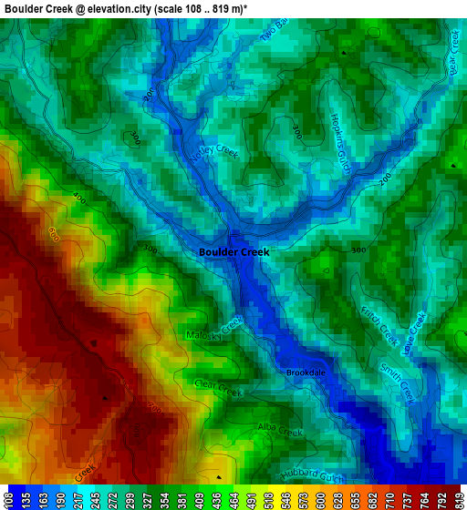
Below is the Elevation map of Boulder Creek, which displays elevation range with different colors. Scale of the first map is from 108 to 819 m (354 to 2687 ft) with average elevation of 364 meters (=1194 ft) [note 1]
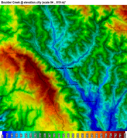
These maps also provides idea of topography and contour of this city, they are displayed at different zoom levels. More info about maps, scale and edge coordinates you can find below images.
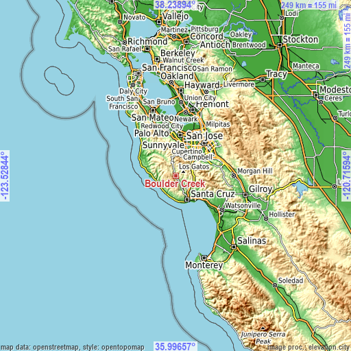
| \ | Map #1 | Map #2 | Topo.Map |
| Scale [m] | 108..819 m | 84..819 m | × |
| Scale [ft] | 354..2687 ft | 276..2687 ft | × |
| Average | 364 m = 1194 ft | 394.4 m = 1294 ft | × |
| Width | 7.79 km = 4.8 mi | 15.58 km = 9.7 mi | 249.3 km = 154.9 mi |
| Height | 7.79 km = 4.8 mi | 15.58 km = 9.7 mi | 249.3 km = 154.9 mi |
| ↑Max Latitude | 37.16109° | 37.196104° | 38.23894° |
| Latitude at center | 37.12606° | 37.12606° | 37.12606° |
| ↓Min Latitude | 37.091014° | 37.055952° | 35.99657° |
| ← Min Longitude | -122.166135° | -122.210081° | -123.52844° |
| Longitude center | -122.12219° | -122.12219° | -122.12219° |
| →Max Longitude | -122.078245° | -122.034299° | -120.71594° |
Nearby cities:
Cities around Boulder Creek sort by population:
• Saratoga elevation 128 m
17.7 km,  29°
29°
• Los Gatos 102 m
17.2 km,  49°
49°
• Scotts Valley 172 m
12.7 km,  131°
131°
• Ben Lomond 105 m
5.2 km,  142°
142°
• Felton 86 m
9.4 km,  152°
152°
• Monte Sereno 154 m
16.8 km,  43°
43°
• Bonny Doon 399 m
9.7 km,  194°
194°
• Lexington Hills 373 m
13.9 km,  72°
72°
• Brookdale 150 m
2.6 km, 146°
• Lompico 217 m
6.6 km,  110°
110°
• Pasatiempo 129 m
16 km, 147°
• Mount Hermon 139 m
10.1 km, 145°
Multilingual:
 En español:
Boulder Creek elevación 148 m.
 En France:
Boulder Creek élévation 148 m.
 Auf Deutsch:
Boulder Creek höhe über dem Meeresspiegel ist 148 m.

Sources and notes:
- [note 1] Map square and city borders are not equal. Map elevation data is calculated only from area inside that square.
- [src 1] Elevation data from geonames database provided with same terms of usage.
- [src 2] The elevation map of Boulder Creek is generated using elevation data from NASA's 3 arcsec (90m) resolution SRTM data.
- [src 3] Base (background) map © OpenStreetMap contributors tiles are generated by Geofabrik and OpenTopoMap.
Copyright & License:
This Boulder Creek Elevation Map is licensed under CC BY-SA. You may reuse any part from this page, if you give a proper credit by linking to this URL:
 More info on terms of use page.