Whiteriver elevation
Whiteriver (Arizona, Navajo County), United States elevation is 1599 meters and Whiteriver elevation in feet is 5246 ft above sea level [src 1]. Whiteriver is a populated place (feature code) with elevation that is 1320 meters (4331 ft) bigger than average city elevation in United States.
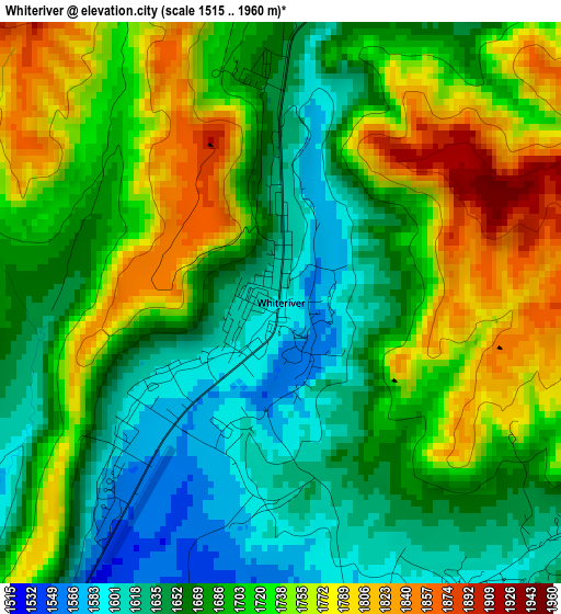
Below is the Elevation map of Whiteriver, which displays elevation range with different colors. Scale of the first map is from 1515 to 1960 m (4970 to 6430 ft) with average elevation of 1698.9 meters (=5574 ft) [note 1]
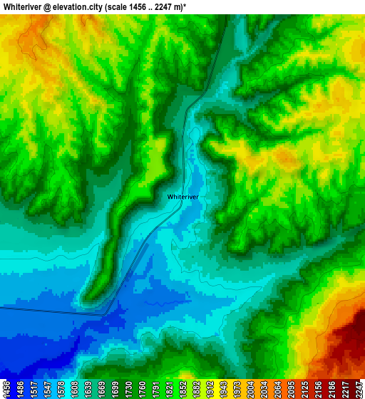
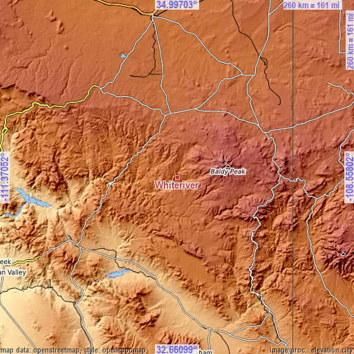
These maps also provides idea of topography and contour of this city, they are displayed at different zoom levels. More info about maps, scale and edge coordinates you can find below images.
| \ | Map #1 | Map #2 | Topo.Map |
| Scale [m] | 1515..1960 m | 1456..2247 m | × |
| Scale [ft] | 4970..6430 ft | 4777..7372 ft | × |
| Average | 1698.9 m = 5574 ft | 1750.2 m = 5742 ft | × |
| Width | 8.12 km = 5 mi | 16.23 km = 10.1 mi | 259.7 km = 161.4 mi |
| Height | 8.12 km = 5 mi | 16.23 km = 10.1 mi | 259.7 km = 161.4 mi |
| ↑Max Latitude | 33.873484° | 33.909963° | 34.99703° |
| Latitude at center | 33.83699° | 33.83699° | 33.83699° |
| ↓Min Latitude | 33.80048° | 33.763955° | 32.66099° |
| ← Min Longitude | -110.008215° | -110.052161° | -111.37052° |
| Longitude center | -109.96427° | -109.96427° | -109.96427° |
| →Max Longitude | -109.920325° | -109.876379° | -108.55802° |
Nearby cities:
Cities around Whiteriver sort by population:
• Show Low elevation 1932 m
46.8 km,  352°
352°
• Eagar 2162 m
69.1 km,  63°
63°
• Pinetop-Lakeside 2079 m
34 km,  0°
0°
• Taylor 1718 m
70.8 km, 350°
• Lake of the Woods 2059 m
36.4 km,  356°
356°
• San Carlos 807 m
71.1 km,  219°
219°
• Linden 1916 m
52.9 km,  340°
340°
• White Mountain Lake 1865 m
57 km, 356°
• Springerville 2119 m
70.5 km, 62°
• Cibecue 1508 m
53.3 km,  295°
295°
• North Fork 2071 m
18.3 km, 0°
• Canyon Day 1527 m
8.2 km, 224°
Multilingual:
 En español:
Whiteriver elevación 1599 m.
 En France:
Whiteriver élévation 1599 m.
 Auf Deutsch:
Whiteriver höhe über dem Meeresspiegel ist 1599 m.

Sources and notes:
- [note 1] Map square and city borders are not equal. Map elevation data is calculated only from area inside that square.
- [src 1] Elevation data from geonames database provided with same terms of usage.
- [src 2] The elevation map of Whiteriver is generated using elevation data from NASA's 3 arcsec (90m) resolution SRTM data.
- [src 3] Base (background) map © OpenStreetMap contributors tiles are generated by Geofabrik and OpenTopoMap.
Copyright & License:
This Whiteriver Elevation Map is licensed under CC BY-SA. You may reuse any part from this page, if you give a proper credit by linking to this URL:
 More info on terms of use page.