Mescal elevation
Mescal (Arizona, Cochise County), United States elevation is 1241 meters and Mescal elevation in feet is 4072 ft above sea level [src 1]. Mescal is a populated place (feature code) with elevation that is 962 meters (3156 ft) bigger than average city elevation in United States.
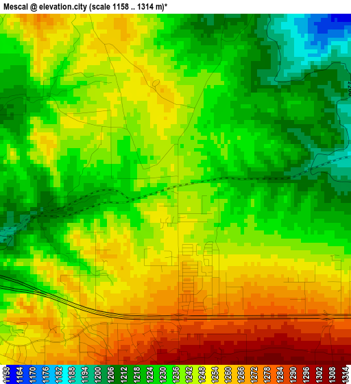
Below is the Elevation map of Mescal, which displays elevation range with different colors. Scale of the first map is from 1158 to 1314 m (3799 to 4311 ft) with average elevation of 1240.7 meters (=4071 ft) [note 1]
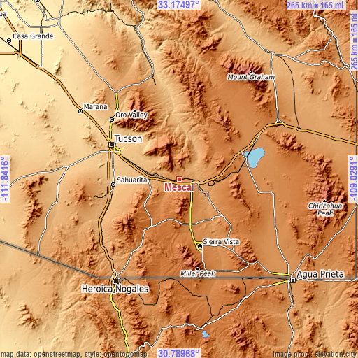
These maps also provides idea of topography and contour of this city, they are displayed at different zoom levels. More info about maps, scale and edge coordinates you can find below images.
| \ | Map #1 | Topo.Map |
| Scale [m] | 1158..1314 m | × |
| Scale [ft] | 3799..4311 ft | × |
| Average | 1240.7 m = 4071 ft | × |
| Width | 8.29 km = 5.2 mi | 265.2 km = 164.8 mi |
| Height | 8.29 km = 5.2 mi | 265.2 km = 164.8 mi |
| ↑Max Latitude | 32.027344° | 33.17497° |
| Latitude at center | 31.99008° | 31.99008° |
| ↓Min Latitude | 31.952801° | 30.78968° |
| ← Min Longitude | -110.479295° | -111.8416° |
| Longitude center | -110.43535° | -110.43535° |
| →Max Longitude | -110.391405° | -109.0291° |
Nearby cities:
Cities around Mescal sort by population:
• Sahuarita elevation 828 m
49.2 km,  265°
265°
• Tanque Verde 809 m
40.7 km,  315°
315°
• Vail 986 m
26.9 km,  283°
283°
• Corona de Tucson 1000 m
32.2 km, 265°
• Summit 799 m
49.4 km, 279°
• Benson 1094 m
13.5 km,  100°
100°
• Whetstone 1330 m
33.4 km,  164°
164°
• Whetstone 1237 m
9.5 km,  112°
112°
• Huachuca City 1347 m
41.4 km,  166°
166°
• Saint David 1126 m
22.9 km, 114°
• East Sahuarita 851 m
46.8 km,  263°
263°
• Tombstone 1389 m
46.4 km,  131°
131°
Multilingual:
 En español:
Mescal elevación 1241 m.
 En France:
Mescal élévation 1241 m.


Sources and notes:
- [note 1] Map square and city borders are not equal. Map elevation data is calculated only from area inside that square.
- [src 1] Elevation data from geonames database provided with same terms of usage.
- [src 2] The elevation map of Mescal is generated using elevation data from NASA's 3 arcsec (90m) resolution SRTM data.
- [src 3] Base (background) map © OpenStreetMap contributors tiles are generated by Geofabrik and OpenTopoMap.
Copyright & License:
This Mescal Elevation Map is licensed under CC BY-SA. You may reuse any part from this page, if you give a proper credit by linking to this URL:
 More info on terms of use page.