Fortuna Foothills elevation
Fortuna Foothills (Arizona, Yuma County), United States elevation is 99 meters and Fortuna Foothills elevation in feet is 325 ft above sea level [src 1]. Fortuna Foothills is a populated place (feature code) with elevation that is 180 meters (591 ft) smaller than average city elevation in United States.
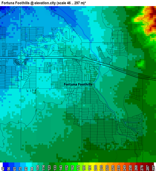
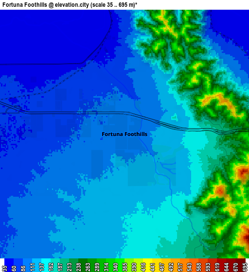
Below is the Elevation map of Fortuna Foothills, which displays elevation range with different colors. Scale of the first map is from 46 to 297 m (151 to 974 ft) with average elevation of 106.6 meters (=350 ft) [note 1]
These maps also provides idea of topography and contour of this city, they are displayed at different zoom levels. More info about maps, scale and edge coordinates you can find below images.
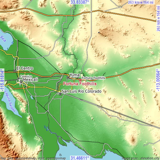
| \ | Map #1 | Map #2 | Topo.Map |
| Scale [m] | 46..297 m | 35..695 m | × |
| Scale [ft] | 151..974 ft | 115..2280 ft | × |
| Average | 106.6 m = 350 ft | 134.8 m = 442 ft | × |
| Width | 8.23 km = 5.1 mi | 16.46 km = 10.2 mi | 263.3 km = 163.6 mi |
| Height | 8.23 km = 5.1 mi | 16.46 km = 10.2 mi | 263.3 km = 163.6 mi |
| ↑Max Latitude | 32.69482° | 32.731795° | 33.83387° |
| Latitude at center | 32.65783° | 32.65783° | 32.65783° |
| ↓Min Latitude | 32.620824° | 32.583804° | 31.46611° |
| ← Min Longitude | -114.455835° | -114.499781° | -115.81814° |
| Longitude center | -114.41189° | -114.41189° | -114.41189° |
| →Max Longitude | -114.367945° | -114.323999° | -113.00564° |
Nearby cities:
Cities around Fortuna Foothills sort by population:
• Yuma elevation 43 m
21.3 km,  290°
290°
• El Centro -14 m
108.7 km,  277°
277°
• Calexico -2 m
101.8 km,  271°
271°
• San Luis 38 m
39.6 km,  241°
241°
• Blythe 82 m
107.3 km,  350°
350°
• Somerton 31 m
28.7 km,  256°
256°
• Holtville -4 m
92.2 km, 280°
• Heber -4 m
104.9 km, 274°
• Avenue B and C 42 m
24.2 km, 286°
• Wellton 73 m
24.9 km,  86°
86°
• Donovan Estates 37 m
25.6 km, 282°
• Ehrenberg 93 m
105.8 km, 354°
Multilingual:
 En español:
Fortuna Foothills elevación 99 m.
 En France:
Fortuna Foothills élévation 99 m.
 Auf Deutsch:
Fortuna Foothills höhe über dem Meeresspiegel ist 99 m.

Sources and notes:
- [note 1] Map square and city borders are not equal. Map elevation data is calculated only from area inside that square.
- [src 1] Elevation data from geonames database provided with same terms of usage.
- [src 2] The elevation map of Fortuna Foothills is generated using elevation data from NASA's 3 arcsec (90m) resolution SRTM data.
- [src 3] Base (background) map © OpenStreetMap contributors tiles are generated by Geofabrik and OpenTopoMap.
Copyright & License:
This Fortuna Foothills Elevation Map is licensed under CC BY-SA. You may reuse any part from this page, if you give a proper credit by linking to this URL:
 More info on terms of use page.