Holbrook elevation
Holbrook (Arizona, Navajo County), United States elevation is 1550 meters and Holbrook elevation in feet is 5085 ft above sea level [src 1]. Holbrook is a seat of a second-order administrative division (feature code) with elevation that is 1271 meters (4170 ft) bigger than average city elevation in United States.
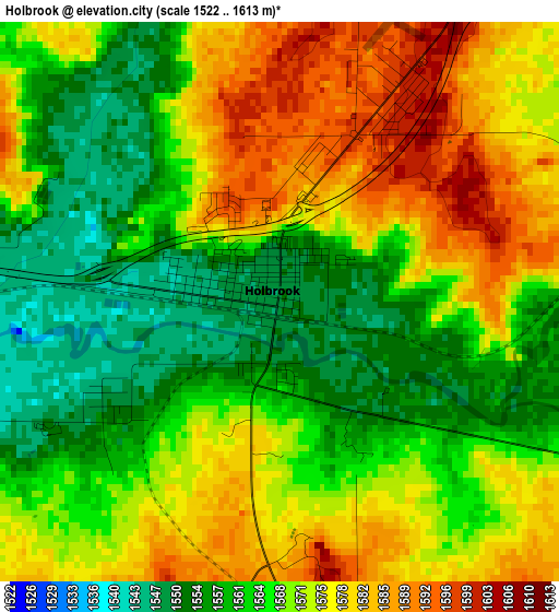
Below is the Elevation map of Holbrook, which displays elevation range with different colors. Scale of the first map is from 1522 to 1613 m (4993 to 5292 ft) with average elevation of 1568.8 meters (=5147 ft) [note 1]
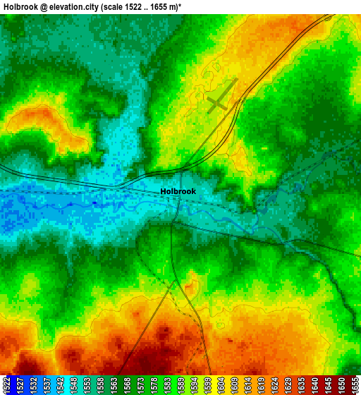
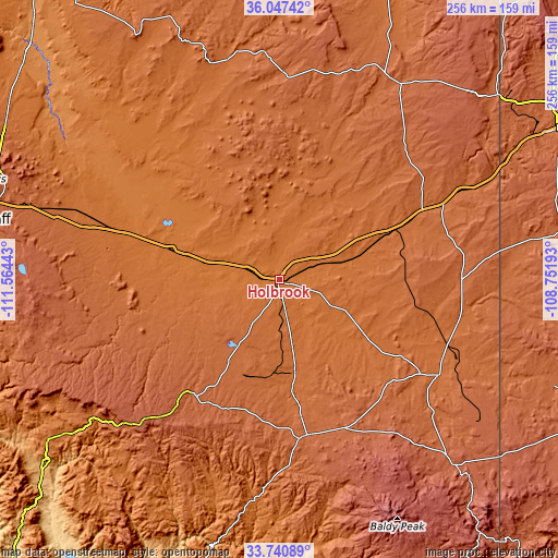
These maps also provides idea of topography and contour of this city, they are displayed at different zoom levels. More info about maps, scale and edge coordinates you can find below images.
| \ | Map #1 | Map #2 | Topo.Map |
| Scale [m] | 1522..1613 m | 1522..1655 m | × |
| Scale [ft] | 4993..5292 ft | 4993..5430 ft | × |
| Average | 1568.8 m = 5147 ft | 1581.3 m = 5188 ft | × |
| Width | 8.01 km = 5 mi | 16.03 km = 10 mi | 256.5 km = 159.4 mi |
| Height | 8.01 km = 5 mi | 16.03 km = 10 mi | 256.5 km = 159.4 mi |
| ↑Max Latitude | 34.938283° | 34.9743° | 36.04742° |
| Latitude at center | 34.90225° | 34.90225° | 34.90225° |
| ↓Min Latitude | 34.866201° | 34.830137° | 33.74089° |
| ← Min Longitude | -110.202125° | -110.246071° | -111.56443° |
| Longitude center | -110.15818° | -110.15818° | -110.15818° |
| →Max Longitude | -110.114235° | -110.070289° | -108.75193° |
Nearby cities:
Cities around Holbrook sort by population:
• Show Low elevation 1932 m
73 km,  170°
170°
• Winslow 1480 m
51 km,  285°
285°
• Snowflake 1703 m
43.8 km, 170°
• Taylor 1718 m
49 km, 172°
• Lake of the Woods 2059 m
83.5 km, 169°
• Saint Johns 1737 m
85.2 km,  121°
121°
• Heber-Overgaard 2021 m
66 km,  214°
214°
• Linden 1916 m
68.6 km,  179°
179°
• White Mountain Lake 1865 m
63.3 km, 166°
• LeChee 1522 m
56.1 km,  284°
284°
• Joseph City 1529 m
17.1 km, 290°
• Dilkon 1798 m
55.7 km,  344°
344°
Multilingual:
 En español:
Holbrook elevación 1550 m.
 En France:
Holbrook élévation 1550 m.
 Auf Deutsch:
Holbrook höhe über dem Meeresspiegel ist 1550 m.

Sources and notes:
- [note 1] Map square and city borders are not equal. Map elevation data is calculated only from area inside that square.
- [src 1] Elevation data from geonames database provided with same terms of usage.
- [src 2] The elevation map of Holbrook is generated using elevation data from NASA's 3 arcsec (90m) resolution SRTM data.
- [src 3] Base (background) map © OpenStreetMap contributors tiles are generated by Geofabrik and OpenTopoMap.
Copyright & License:
This Holbrook Elevation Map is licensed under CC BY-SA. You may reuse any part from this page, if you give a proper credit by linking to this URL:
 More info on terms of use page.