Fredonia elevation
Fredonia (Wisconsin, Ozaukee County), United States elevation is 250 meters and Fredonia elevation in feet is 820 ft above sea level [src 1]. Fredonia is a populated place (feature code) with elevation that is 29 meters (95 ft) smaller than average city elevation in United States.
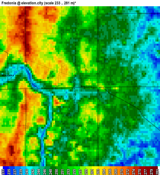
Below is the Elevation map of Fredonia, which displays elevation range with different colors. Scale of the first map is from 233 to 281 m (764 to 922 ft) with average elevation of 252.4 meters (=828 ft) [note 1]
These maps also provides idea of topography and contour of this city, they are displayed at different zoom levels. More info about maps, scale and edge coordinates you can find below images.
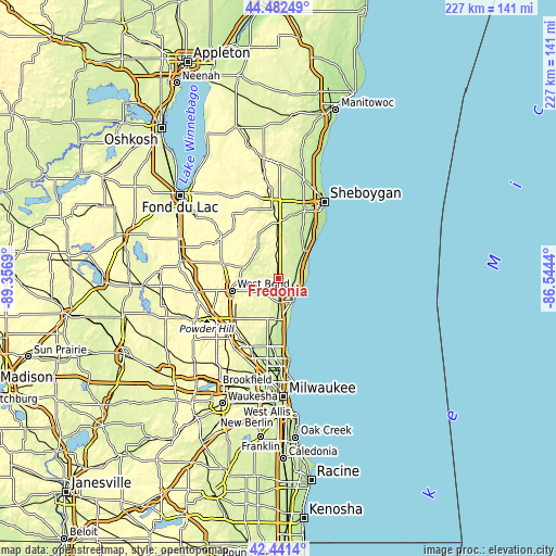
| \ | Map #1 | Topo.Map |
| Scale [m] | 233..281 m | × |
| Scale [ft] | 764..922 ft | × |
| Average | 252.4 m = 828 ft | × |
| Width | 7.09 km = 4.4 mi | 226.9 km = 141 mi |
| Height | 7.09 km = 4.4 mi | 226.9 km = 141 mi |
| ↑Max Latitude | 43.502444° | 44.48249° |
| Latitude at center | 43.47056° | 43.47056° |
| ↓Min Latitude | 43.438659° | 42.4414° |
| ← Min Longitude | -87.994595° | -89.3569° |
| Longitude center | -87.95065° | -87.95065° |
| →Max Longitude | -87.906705° | -86.5444° |
Nearby cities:
Cities around Fredonia sort by population:
• West Bend elevation 277 m
19.5 km,  255°
255°
• Port Washington 187 m
11.1 km,  146°
146°
• Grafton 232 m
16.8 km,  180°
180°
• Cedarburg 239 m
19.6 km,  188°
188°
• Saukville 231 m
9.9 km, 175°
• Oostburg 215 m
21.1 km,  36°
36°
• Barton 282 m
18.8 km, 260°
• Belgium 225 m
8.7 km,  68°
68°
• Cedar Grove 221 m
15.1 km, 42°
• Kohler 267 m
6.5 km,  296°
296°
• Random Lake 273 m
9.1 km,  354°
354°
• Newburg 260 m
8.9 km,  240°
240°
Multilingual:
 En español:
Fredonia elevación 250 m.
 En France:
Fredonia élévation 250 m.
 Auf Deutsch:
Fredonia höhe über dem Meeresspiegel ist 250 m.

Sources and notes:
- [note 1] Map square and city borders are not equal. Map elevation data is calculated only from area inside that square.
- [src 1] Elevation data from geonames database provided with same terms of usage.
- [src 2] The elevation map of Fredonia is generated using elevation data from NASA's 3 arcsec (90m) resolution SRTM data.
- [src 3] Base (background) map © OpenStreetMap contributors tiles are generated by Geofabrik and OpenTopoMap.
Copyright & License:
This Fredonia Elevation Map is licensed under CC BY-SA. You may reuse any part from this page, if you give a proper credit by linking to this URL:
 More info on terms of use page.