Dane elevation
Dane (Wisconsin, Dane County), United States elevation is 325 meters and Dane elevation in feet is 1066 ft above sea level [src 1]. Dane is a populated place (feature code) with elevation that is 46 meters (151 ft) bigger than average city elevation in United States.
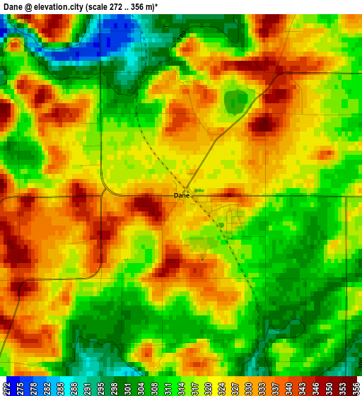
Below is the Elevation map of Dane, which displays elevation range with different colors. Scale of the first map is from 272 to 356 m (892 to 1168 ft) with average elevation of 318.9 meters (=1046 ft) [note 1]
These maps also provides idea of topography and contour of this city, they are displayed at different zoom levels. More info about maps, scale and edge coordinates you can find below images.
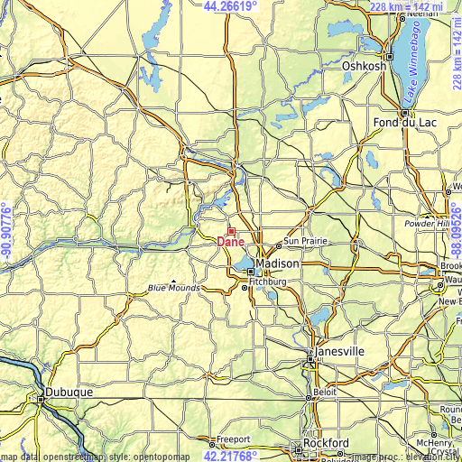
| \ | Map #1 | Topo.Map |
| Scale [m] | 272..356 m | × |
| Scale [ft] | 892..1168 ft | × |
| Average | 318.9 m = 1046 ft | × |
| Width | 7.12 km = 4.4 mi | 227.8 km = 141.5 mi |
| Height | 7.12 km = 4.4 mi | 227.8 km = 141.5 mi |
| ↑Max Latitude | 43.28255° | 44.26619° |
| Latitude at center | 43.25055° | 43.25055° |
| ↓Min Latitude | 43.218533° | 42.21768° |
| ← Min Longitude | -89.545455° | -90.90776° |
| Longitude center | -89.50151° | -89.50151° |
| →Max Longitude | -89.457565° | -88.09526° |
Nearby cities:
Cities around Dane sort by population:
• Middleton elevation 291 m
17.1 km,  180°
180°
• Waunakee 285 m
7.5 km,  150°
150°
• De Forest 290 m
12.8 km,  91°
91°
• Prairie du Sac 238 m
18.5 km,  282°
282°
• Lake Wisconsin 269 m
14.9 km,  336°
336°
• Cross Plains 265 m
19.6 km,  219°
219°
• Windsor 276 m
13.4 km,  105°
105°
• Sauk City 227 m
18 km, 277°
• Lodi 251 m
7.3 km, 343°
• Poynette 258 m
17.5 km,  27°
27°
• Roxbury 264 m
14.1 km,  269°
269°
• Maple Bluff 274 m
17.7 km, 146°
Multilingual:
 En español:
Dane elevación 325 m.
 En France:
Dane élévation 325 m.


Sources and notes:
- [note 1] Map square and city borders are not equal. Map elevation data is calculated only from area inside that square.
- [src 1] Elevation data from geonames database provided with same terms of usage.
- [src 2] The elevation map of Dane is generated using elevation data from NASA's 3 arcsec (90m) resolution SRTM data.
- [src 3] Base (background) map © OpenStreetMap contributors tiles are generated by Geofabrik and OpenTopoMap.
Copyright & License:
This Dane Elevation Map is licensed under CC BY-SA. You may reuse any part from this page, if you give a proper credit by linking to this URL:
 More info on terms of use page.