Blair elevation
Blair (Wisconsin, Trempealeau County), United States elevation is 261 meters and Blair elevation in feet is 856 ft above sea level [src 1]. Blair is a populated place (feature code) with elevation that is 18 meters (59 ft) smaller than average city elevation in United States.
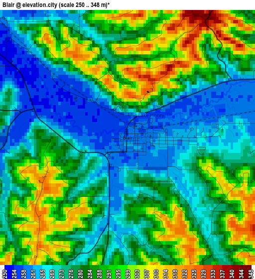
Below is the Elevation map of Blair, which displays elevation range with different colors. Scale of the first map is from 250 to 348 m (820 to 1142 ft) with average elevation of 282.4 meters (=927 ft) [note 1]
These maps also provides idea of topography and contour of this city, they are displayed at different zoom levels. More info about maps, scale and edge coordinates you can find below images.
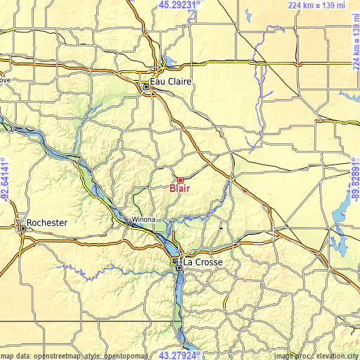
| \ | Map #1 | Topo.Map |
| Scale [m] | 250..348 m | × |
| Scale [ft] | 820..1142 ft | × |
| Average | 282.4 m = 927 ft | × |
| Width | 6.99 km = 4.3 mi | 223.8 km = 139.1 mi |
| Height | 6.99 km = 4.3 mi | 223.8 km = 139.1 mi |
| ↑Max Latitude | 44.325846° | 45.29231° |
| Latitude at center | 44.2944° | 44.2944° |
| ↓Min Latitude | 44.262937° | 43.27924° |
| ← Min Longitude | -91.279105° | -92.64141° |
| Longitude center | -91.23516° | -91.23516° |
| →Max Longitude | -91.191215° | -89.82891° |
Nearby cities:
Cities around Blair sort by population:
• Winona elevation 202 m
42.2 km,  229°
229°
• Holmen 218 m
36.9 km,  182°
182°
• Black River Falls 244 m
30.5 km,  89°
89°
• Arcadia 221 m
21.7 km,  257°
257°
• Brice Prairie 204 m
39.9 km,  187°
187°
• Osseo 292 m
30.9 km,  1°
1°
• Trempealeau 213 m
36.1 km,  207°
207°
• Whitehall 249 m
10.4 km,  321°
321°
• Galesville 222 m
25.3 km,  200°
200°
• Augusta 290 m
43.9 km,  12°
12°
• Independence 239 m
16.3 km,  295°
295°
• Strum 275 m
31 km,  336°
336°
Multilingual:
 En español:
Blair elevación 261 m.
 En France:
Blair élévation 261 m.


Sources and notes:
- [note 1] Map square and city borders are not equal. Map elevation data is calculated only from area inside that square.
- [src 1] Elevation data from geonames database provided with same terms of usage.
- [src 2] The elevation map of Blair is generated using elevation data from NASA's 3 arcsec (90m) resolution SRTM data.
- [src 3] Base (background) map © OpenStreetMap contributors tiles are generated by Geofabrik and OpenTopoMap.
Copyright & License:
This Blair Elevation Map is licensed under CC BY-SA. You may reuse any part from this page, if you give a proper credit by linking to this URL:
 More info on terms of use page.