Ashwaubenon elevation
Ashwaubenon (Wisconsin, Brown County), United States elevation is 185 meters and Ashwaubenon elevation in feet is 607 ft above sea level [src 1]. Ashwaubenon is a populated place (feature code) with elevation that is 94 meters (308 ft) smaller than average city elevation in United States.
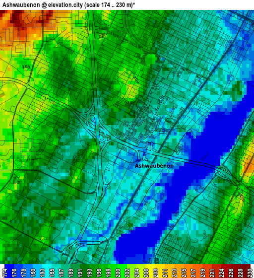
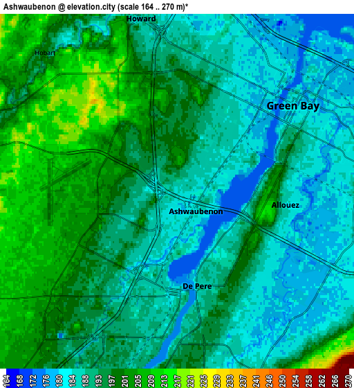
Below is the Elevation map of Ashwaubenon, which displays elevation range with different colors. Scale of the first map is from 174 to 230 m (571 to 755 ft) with average elevation of 190.6 meters (=625 ft) [note 1]
These maps also provides idea of topography and contour of this city, they are displayed at different zoom levels. More info about maps, scale and edge coordinates you can find below images.
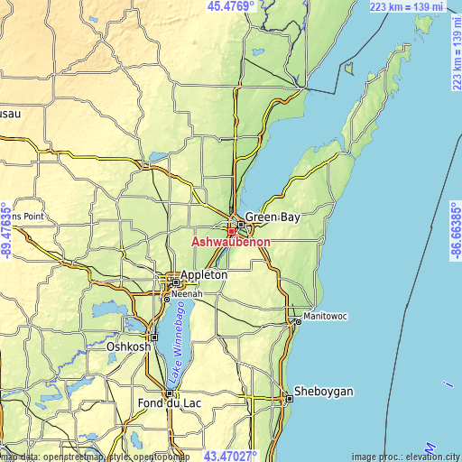
| \ | Map #1 | Map #2 | Topo.Map |
| Scale [m] | 174..230 m | 164..270 m | × |
| Scale [ft] | 571..755 ft | 538..886 ft | × |
| Average | 190.6 m = 625 ft | 192.9 m = 633 ft | × |
| Width | 6.97 km = 4.3 mi | 13.94 km = 8.7 mi | 223.1 km = 138.6 mi |
| Height | 6.97 km = 4.3 mi | 13.94 km = 8.7 mi | 223.1 km = 138.6 mi |
| ↑Max Latitude | 44.513555° | 44.544883° | 45.4769° |
| Latitude at center | 44.48221° | 44.48221° | 44.48221° |
| ↓Min Latitude | 44.450848° | 44.419469° | 43.47027° |
| ← Min Longitude | -88.114045° | -88.157991° | -89.47635° |
| Longitude center | -88.0701° | -88.0701° | -88.0701° |
| →Max Longitude | -88.026155° | -87.982209° | -86.66385° |
Nearby cities:
Cities around Ashwaubenon sort by population:
• Green Bay elevation 182 m
5.7 km,  44°
44°
• De Pere 188 m
3.8 km,  168°
168°
• Howard 187 m
7 km,  348°
348°
• Bellevue 231 m
12.6 km,  109°
109°
• Allouez 184 m
4.3 km,  96°
96°
• Suamico 182 m
16.8 km,  8°
8°
• Hobart 217 m
6.6 km,  286°
286°
• Seymour 243 m
21 km,  280°
280°
• Wrightstown 191 m
18.9 km,  202°
202°
• Pittsfield 243 m
19 km,  313°
313°
• Oneida 207 m
9.1 km, 281°
• Glenmore 280 m
15.6 km,  133°
133°
Multilingual:
 En español:
Ashwaubenon elevación 185 m.
 En France:
Ashwaubenon élévation 185 m.
 Auf Deutsch:
Ashwaubenon höhe über dem Meeresspiegel ist 185 m.

Sources and notes:
- [note 1] Map square and city borders are not equal. Map elevation data is calculated only from area inside that square.
- [src 1] Elevation data from geonames database provided with same terms of usage.
- [src 2] The elevation map of Ashwaubenon is generated using elevation data from NASA's 3 arcsec (90m) resolution SRTM data.
- [src 3] Base (background) map © OpenStreetMap contributors tiles are generated by Geofabrik and OpenTopoMap.
Copyright & License:
This Ashwaubenon Elevation Map is licensed under CC BY-SA. You may reuse any part from this page, if you give a proper credit by linking to this URL:
 More info on terms of use page.