Ferrisburgh elevation
Ferrisburgh (Vermont, Addison County), United States elevation is 65 meters and Ferrisburgh elevation in feet is 213 ft above sea level [src 1]. Ferrisburgh is a populated place (feature code) with elevation that is 214 meters (702 ft) smaller than average city elevation in United States.
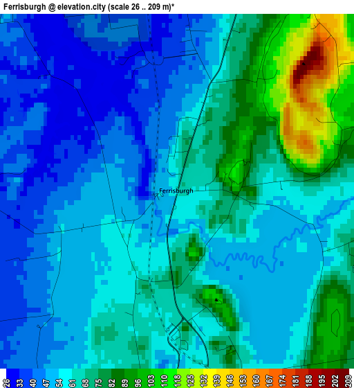
Below is the Elevation map of Ferrisburgh, which displays elevation range with different colors. Scale of the first map is from 26 to 209 m (85 to 686 ft) with average elevation of 62 meters (=203 ft) [note 1]
These maps also provides idea of topography and contour of this city, they are displayed at different zoom levels. More info about maps, scale and edge coordinates you can find below images.
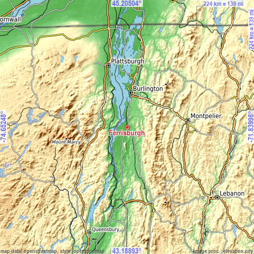
| \ | Map #1 | Topo.Map |
| Scale [m] | 26..209 m | × |
| Scale [ft] | 85..686 ft | × |
| Average | 62 m = 203 ft | × |
| Width | 7.01 km = 4.4 mi | 224.2 km = 139.3 mi |
| Height | 7.01 km = 4.4 mi | 224.2 km = 139.3 mi |
| ↑Max Latitude | 44.237103° | 45.20504° |
| Latitude at center | 44.20561° | 44.20561° |
| ↓Min Latitude | 44.1741° | 43.18893° |
| ← Min Longitude | -73.290175° | -74.65248° |
| Longitude center | -73.24623° | -73.24623° |
| →Max Longitude | -73.202285° | -71.83998° |
Nearby cities:
Cities around Ferrisburgh sort by population:
• Middlebury (village) elevation 111 m
22 km,  163°
163°
• Hinesburg 104 m
17.5 km,  38°
38°
• Charlotte 51 m
11.6 km,  354°
354°
• Vergennes 59 m
4.3 km,  188°
188°
• Bristol 175 m
15.6 km,  121°
121°
• Starksboro 188 m
15.2 km,  80°
80°
• Addison 89 m
13.8 km,  199°
199°
• Mineville 395 m
25.1 km,  239°
239°
• Lincoln 300 m
22.8 km, 119°
• Bridport 90 m
25.1 km, 192°
• Port Henry 76 m
24.4 km,  224°
224°
• Elizabethtown 176 m
27.5 km,  272°
272°
Multilingual:
 En español:
Ferrisburgh elevación 65 m.
 En France:
Ferrisburgh élévation 65 m.
 Auf Deutsch:
Ferrisburgh höhe über dem Meeresspiegel ist 65 m.

Sources and notes:
- [note 1] Map square and city borders are not equal. Map elevation data is calculated only from area inside that square.
- [src 1] Elevation data from geonames database provided with same terms of usage.
- [src 2] The elevation map of Ferrisburgh is generated using elevation data from NASA's 3 arcsec (90m) resolution SRTM data.
- [src 3] Base (background) map © OpenStreetMap contributors tiles are generated by Geofabrik and OpenTopoMap.
Copyright & License:
This Ferrisburgh Elevation Map is licensed under CC BY-SA. You may reuse any part from this page, if you give a proper credit by linking to this URL:
 More info on terms of use page.