Mitchell elevation
Mitchell (South Dakota, Davison County), United States elevation is 398 meters and Mitchell elevation in feet is 1306 ft above sea level [src 1]. Mitchell is a seat of a second-order administrative division (feature code) with elevation that is 119 meters (390 ft) bigger than average city elevation in United States.
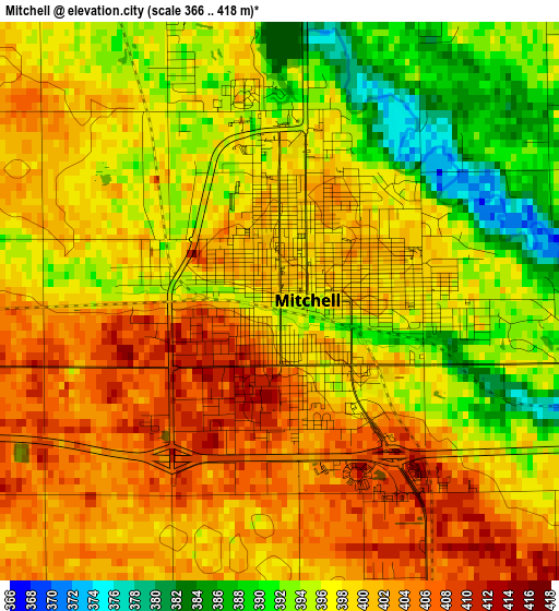
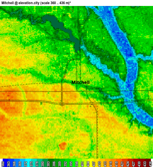
Below is the Elevation map of Mitchell, which displays elevation range with different colors. Scale of the first map is from 366 to 418 m (1201 to 1371 ft) with average elevation of 398 meters (=1306 ft) [note 1]
These maps also provides idea of topography and contour of this city, they are displayed at different zoom levels. More info about maps, scale and edge coordinates you can find below images.
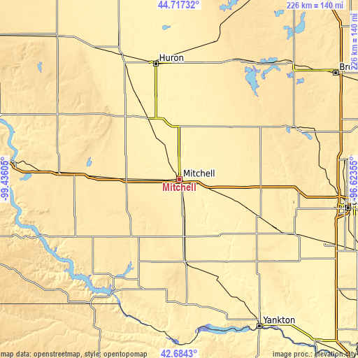
| \ | Map #1 | Map #2 | Topo.Map |
| Scale [m] | 366..418 m | 360..436 m | × |
| Scale [ft] | 1201..1371 ft | 1181..1430 ft | × |
| Average | 398 m = 1306 ft | 396.8 m = 1302 ft | × |
| Width | 7.06 km = 4.4 mi | 14.13 km = 8.8 mi | 226.1 km = 140.5 mi |
| Height | 7.06 km = 4.4 mi | 14.13 km = 8.8 mi | 226 km = 140.4 mi |
| ↑Max Latitude | 43.741188° | 43.772928° | 44.71732° |
| Latitude at center | 43.70943° | 43.70943° | 43.70943° |
| ↓Min Latitude | 43.677656° | 43.645864° | 42.6843° |
| ← Min Longitude | -98.073745° | -98.117691° | -99.43605° |
| Longitude center | -98.0298° | -98.0298° | -98.0298° |
| →Max Longitude | -97.985855° | -97.941909° | -96.62355° |
Nearby cities:
Cities around Mitchell sort by population:
• Wagner elevation 441 m
73.2 km,  196°
196°
• Parkston 423 m
34.7 km,  173°
173°
• Salem 464 m
51.5 km,  88°
88°
• Freeman 463 m
62.1 km,  129°
129°
• Wessington Springs 510 m
59.7 km,  313°
313°
• Lake Andes 454 m
74.1 km,  213°
213°
• Howard 479 m
52.4 km,  50°
50°
• Plankinton 464 m
36.6 km,  271°
271°
• Armour 465 m
50.4 km, 210°
• Woonsocket 398 m
43 km,  332°
332°
• Alexandria 413 m
20.8 km,  107°
107°
• Olivet 375 m
59.4 km,  151°
151°
Multilingual:
 En español:
Mitchell elevación 398 m.
 En France:
Mitchell élévation 398 m.
 Auf Deutsch:
Mitchell höhe über dem Meeresspiegel ist 398 m.

Sources and notes:
- [note 1] Map square and city borders are not equal. Map elevation data is calculated only from area inside that square.
- [src 1] Elevation data from geonames database provided with same terms of usage.
- [src 2] The elevation map of Mitchell is generated using elevation data from NASA's 3 arcsec (90m) resolution SRTM data.
- [src 3] Base (background) map © OpenStreetMap contributors tiles are generated by Geofabrik and OpenTopoMap.
Copyright & License:
This Mitchell Elevation Map is licensed under CC BY-SA. You may reuse any part from this page, if you give a proper credit by linking to this URL:
 More info on terms of use page.