Elk Point elevation
Elk Point (South Dakota, Union County), United States elevation is 344 meters and Elk Point elevation in feet is 1129 ft above sea level [src 1]. Elk Point is a seat of a second-order administrative division (feature code) with elevation that is 65 meters (213 ft) bigger than average city elevation in United States.
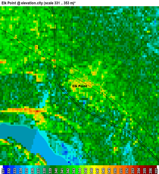
Below is the Elevation map of Elk Point, which displays elevation range with different colors. Scale of the first map is from 331 to 353 m (1086 to 1158 ft) with average elevation of 339.9 meters (=1115 ft) [note 1]
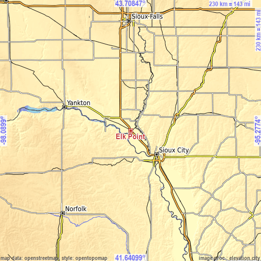
These maps also provides idea of topography and contour of this city, they are displayed at different zoom levels. More info about maps, scale and edge coordinates you can find below images.
| \ | Map #1 | Topo.Map |
| Scale [m] | 331..353 m | × |
| Scale [ft] | 1086..1158 ft | × |
| Average | 339.9 m = 1115 ft | × |
| Width | 7.18 km = 4.5 mi | 229.9 km = 142.9 mi |
| Height | 7.18 km = 4.5 mi | 229.9 km = 142.9 mi |
| ↑Max Latitude | 42.715626° | 43.70847° |
| Latitude at center | 42.68333° | 42.68333° |
| ↓Min Latitude | 42.651017° | 41.64099° |
| ← Min Longitude | -96.727595° | -98.0899° |
| Longitude center | -96.68365° | -96.68365° |
| →Max Longitude | -96.639705° | -95.2774° |
Nearby cities:
Cities around Elk Point sort by population:
• Sioux City elevation 364 m
30.9 km,  131°
131°
• South Sioux City 333 m
32.1 km,  136°
136°
• Vermillion 374 m
22.7 km,  298°
298°
• Le Mars 374 m
44.1 km,  73°
73°
• Sergeant Bluff 331 m
40.9 km, 139°
• North Sioux City 333 m
23.9 km, 136°
• Hawarden 360 m
38.3 km,  24°
24°
• Dakota Dunes 336 m
27.1 km, 143°
• Beresford 459 m
44.8 km,  350°
350°
• Dakota City 333 m
36.9 km, 143°
• Akron 346 m
19.1 km,  32°
32°
• Ponca 346 m
13.6 km,  187°
187°
Multilingual:
 En español:
Elk Point elevación 344 m.
 En France:
Elk Point élévation 344 m.
 Auf Deutsch:
Elk Point höhe über dem Meeresspiegel ist 344 m.

Sources and notes:
- [note 1] Map square and city borders are not equal. Map elevation data is calculated only from area inside that square.
- [src 1] Elevation data from geonames database provided with same terms of usage.
- [src 2] The elevation map of Elk Point is generated using elevation data from NASA's 3 arcsec (90m) resolution SRTM data.
- [src 3] Base (background) map © OpenStreetMap contributors tiles are generated by Geofabrik and OpenTopoMap.
Copyright & License:
This Elk Point Elevation Map is licensed under CC BY-SA. You may reuse any part from this page, if you give a proper credit by linking to this URL:
 More info on terms of use page.