Woonsocket elevation
Woonsocket (Rhode Island, Providence County), United States elevation is 55 meters and Woonsocket elevation in feet is 180 ft above sea level [src 1]. Woonsocket is a populated place (feature code) with elevation that is 224 meters (735 ft) smaller than average city elevation in United States.
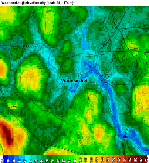
Below is the Elevation map of Woonsocket, which displays elevation range with different colors. Scale of the first map is from 24 to 174 m (79 to 571 ft) with average elevation of 78.2 meters (=257 ft) [note 1]
These maps also provides idea of topography and contour of this city, they are displayed at different zoom levels. More info about maps, scale and edge coordinates you can find below images.
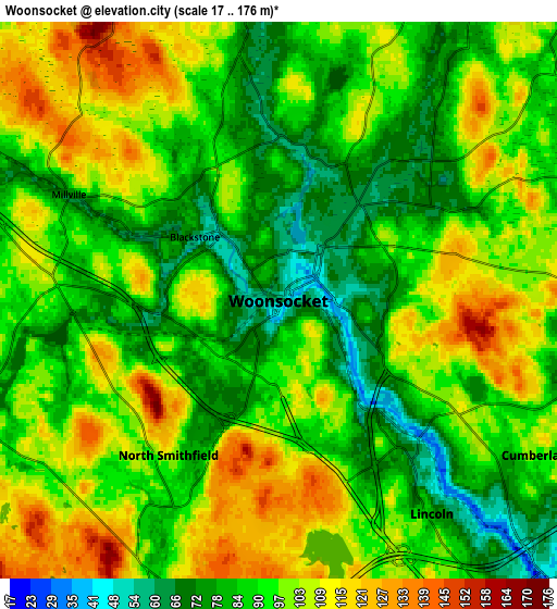
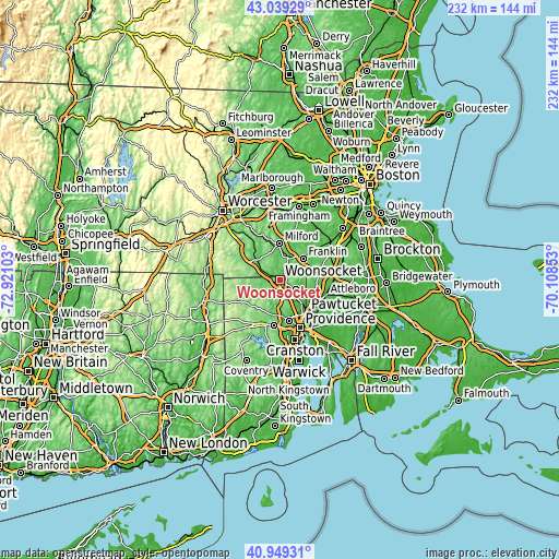
| \ | Map #1 | Map #2 | Topo.Map |
| Scale [m] | 24..174 m | 17..176 m | × |
| Scale [ft] | 79..571 ft | 56..577 ft | × |
| Average | 78.2 m = 257 ft | 94.6 m = 310 ft | × |
| Width | 7.26 km = 4.5 mi | 14.52 km = 9 mi | 232.4 km = 144.4 mi |
| Height | 7.26 km = 4.5 mi | 14.52 km = 9 mi | 232.4 km = 144.4 mi |
| ↑Max Latitude | 42.035528° | 42.068159° | 43.03929° |
| Latitude at center | 42.00288° | 42.00288° | 42.00288° |
| ↓Min Latitude | 41.970215° | 41.937534° | 40.94931° |
| ← Min Longitude | -71.558725° | -71.602671° | -72.92103° |
| Longitude center | -71.51478° | -71.51478° | -71.51478° |
| →Max Longitude | -71.470835° | -71.426889° | -70.10853° |
Nearby cities:
Cities around Woonsocket sort by population:
• Cumberland elevation 93 m
7.9 km,  120°
120°
• Franklin 94 m
13.2 km,  47°
47°
• Smithfield 82 m
9.4 km,  197°
197°
• Lincoln 42 m
11.2 km,  144°
144°
• Uxbridge 76 m
12.6 km,  311°
311°
• North Smithfield 105 m
4.9 km,  215°
215°
• Blackstone 55 m
2.7 km, 307°
• Cumberland Hill 70 m
5.1 km,  128°
128°
• Mendon 112 m
11.8 km,  344°
344°
• Bellingham 95 m
9.9 km,  19°
19°
• Millville 72 m
6.1 km,  296°
296°
• Harrisville 101 m
13.8 km,  252°
252°
Multilingual:
 En español:
Woonsocket elevación 55 m.
 En France:
Woonsocket élévation 55 m.
 Auf Deutsch:
Woonsocket höhe über dem Meeresspiegel ist 55 m.

Sources and notes:
- [note 1] Map square and city borders are not equal. Map elevation data is calculated only from area inside that square.
- [src 1] Elevation data from geonames database provided with same terms of usage.
- [src 2] The elevation map of Woonsocket is generated using elevation data from NASA's 3 arcsec (90m) resolution SRTM data.
- [src 3] Base (background) map © OpenStreetMap contributors tiles are generated by Geofabrik and OpenTopoMap.
Copyright & License:
This Woonsocket Elevation Map is licensed under CC BY-SA. You may reuse any part from this page, if you give a proper credit by linking to this URL:
 More info on terms of use page.