West Easton elevation
West Easton (Pennsylvania, Northampton County), United States elevation is 89 meters and West Easton elevation in feet is 292 ft above sea level [src 1]. West Easton is a populated place (feature code) with elevation that is 190 meters (623 ft) smaller than average city elevation in United States.
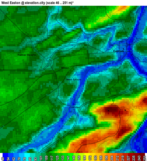
Below is the Elevation map of West Easton, which displays elevation range with different colors. Scale of the first map is from 46 to 251 m (151 to 823 ft) with average elevation of 114.9 meters (=377 ft) [note 1]
These maps also provides idea of topography and contour of this city, they are displayed at different zoom levels. More info about maps, scale and edge coordinates you can find below images.
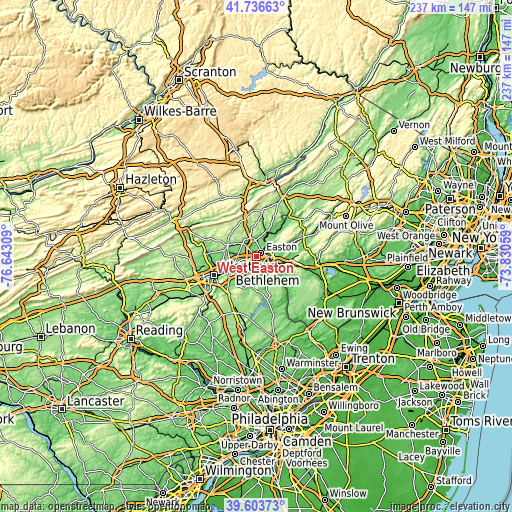
| \ | Map #1 | Topo.Map |
| Scale [m] | 46..251 m | × |
| Scale [ft] | 151..823 ft | × |
| Average | 114.9 m = 377 ft | × |
| Width | 7.41 km = 4.6 mi | 237.2 km = 147.4 mi |
| Height | 7.41 km = 4.6 mi | 237.1 km = 147.3 mi |
| ↑Max Latitude | 40.712029° | 41.73663° |
| Latitude at center | 40.67871° | 40.67871° |
| ↓Min Latitude | 40.645375° | 39.60373° |
| ← Min Longitude | -75.280785° | -76.64309° |
| Longitude center | -75.23684° | -75.23684° |
| →Max Longitude | -75.192895° | -73.83059° |
Nearby cities:
Cities around West Easton sort by population:
• Easton elevation 103 m
1.7 km,  51°
51°
• Phillipsburg 102 m
4.3 km,  67°
67°
• Wilson 125 m
0.7 km,  324°
324°
• Middletown 84 m
8.9 km,  244°
244°
• Nazareth 155 m
9.2 km, 318°
• Palmer Heights 114 m
2.4 km,  293°
293°
• Eastlawn Gardens 150 m
9.4 km,  328°
328°
• Old Orchard 132 m
3.1 km,  222°
222°
• Alpha 101 m
6.8 km,  100°
100°
• Upper Pohatcong 99 m
6.8 km,  91°
91°
• Tatamy 123 m
7.1 km,  346°
346°
• Raubsville 60 m
6.1 km,  142°
142°
Multilingual:
 En español:
West Easton elevación 89 m.
 En France:
West Easton élévation 89 m.
 Auf Deutsch:
West Easton höhe über dem Meeresspiegel ist 89 m.

Sources and notes:
- [note 1] Map square and city borders are not equal. Map elevation data is calculated only from area inside that square.
- [src 1] Elevation data from geonames database provided with same terms of usage.
- [src 2] The elevation map of West Easton is generated using elevation data from NASA's 3 arcsec (90m) resolution SRTM data.
- [src 3] Base (background) map © OpenStreetMap contributors tiles are generated by Geofabrik and OpenTopoMap.
Copyright & License:
This West Easton Elevation Map is licensed under CC BY-SA. You may reuse any part from this page, if you give a proper credit by linking to this URL:
 More info on terms of use page.