Vandergrift elevation
Vandergrift (Pennsylvania, Westmoreland County), United States elevation is 274 meters and Vandergrift elevation in feet is 899 ft above sea level [src 1]. Vandergrift is a populated place (feature code) with elevation that is 5 meters (16 ft) smaller than average city elevation in United States.
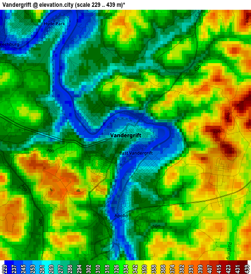
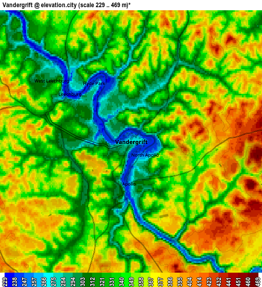
Below is the Elevation map of Vandergrift, which displays elevation range with different colors. Scale of the first map is from 229 to 439 m (751 to 1440 ft) with average elevation of 317.2 meters (=1041 ft) [note 1]
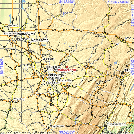
These maps also provides idea of topography and contour of this city, they are displayed at different zoom levels. More info about maps, scale and edge coordinates you can find below images.
| \ | Map #1 | Map #2 | Topo.Map |
| Scale [m] | 229..439 m | 229..469 m | × |
| Scale [ft] | 751..1440 ft | 751..1539 ft | × |
| Average | 317.2 m = 1041 ft | 348.5 m = 1143 ft | × |
| Width | 7.42 km = 4.6 mi | 14.84 km = 9.2 mi | 237.4 km = 147.5 mi |
| Height | 7.42 km = 4.6 mi | 14.84 km = 9.2 mi | 237.4 km = 147.5 mi |
| ↑Max Latitude | 40.636197° | 40.669537° | 41.66198° |
| Latitude at center | 40.60284° | 40.60284° | 40.60284° |
| ↓Min Latitude | 40.569467° | 40.536077° | 39.52665° |
| ← Min Longitude | -79.608715° | -79.652661° | -80.97102° |
| Longitude center | -79.56477° | -79.56477° | -79.56477° |
| →Max Longitude | -79.520825° | -79.476879° | -78.15852° |
Nearby cities:
Cities around Vandergrift sort by population:
• New Kensington elevation 239 m
17.3 km,  257°
257°
• Lower Burrell 228 m
17.2 km,  251°
251°
• Arnold 240 m
17.2 km, 261°
• Tarentum 243 m
16.5 km,  269°
269°
• Brackenridge 255 m
14.9 km, 272°
• Leechburg 243 m
4.4 km,  307°
307°
• Orchard Hills 348 m
3.4 km,  123°
123°
• Freeport 244 m
12.8 km, 307°
• Apollo 251 m
2.4 km,  183°
183°
• West Leechburg 308 m
4.6 km,  298°
298°
• North Apollo 251 m
1.1 km,  133°
133°
• Lenape Heights 298 m
18.3 km,  11°
11°
Multilingual:
 En español:
Vandergrift elevación 274 m.
 En France:
Vandergrift élévation 274 m.
 Auf Deutsch:
Vandergrift höhe über dem Meeresspiegel ist 274 m.

Sources and notes:
- [note 1] Map square and city borders are not equal. Map elevation data is calculated only from area inside that square.
- [src 1] Elevation data from geonames database provided with same terms of usage.
- [src 2] The elevation map of Vandergrift is generated using elevation data from NASA's 3 arcsec (90m) resolution SRTM data.
- [src 3] Base (background) map © OpenStreetMap contributors tiles are generated by Geofabrik and OpenTopoMap.
Copyright & License:
This Vandergrift Elevation Map is licensed under CC BY-SA. You may reuse any part from this page, if you give a proper credit by linking to this URL:
 More info on terms of use page.