Trevose elevation
Trevose (Pennsylvania, Bucks County), United States elevation is 48 meters and Trevose elevation in feet is 157 ft above sea level [src 1]. Trevose is a populated place (feature code) with elevation that is 231 meters (758 ft) smaller than average city elevation in United States.
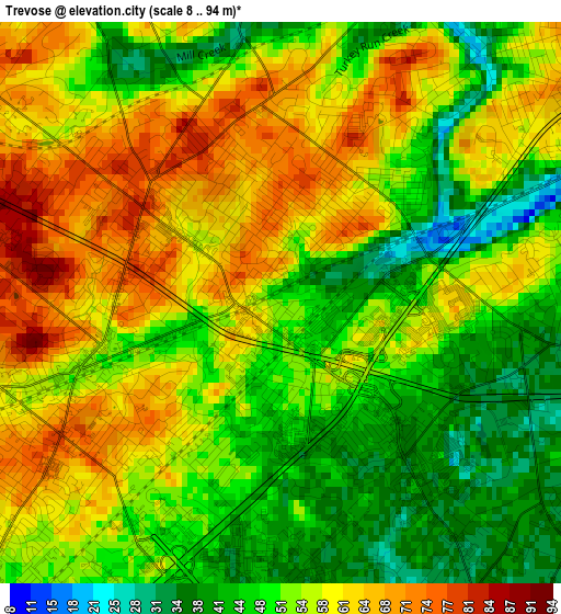
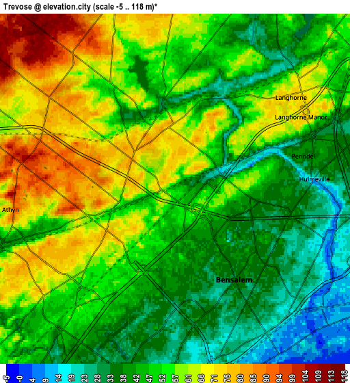
Below is the Elevation map of Trevose, which displays elevation range with different colors. Scale of the first map is from 8 to 94 m (26 to 308 ft) with average elevation of 54.3 meters (=178 ft) [note 1]
These maps also provides idea of topography and contour of this city, they are displayed at different zoom levels. More info about maps, scale and edge coordinates you can find below images.
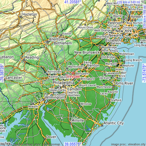
| \ | Map #1 | Map #2 | Topo.Map |
| Scale [m] | 8..94 m | -5..118 m | × |
| Scale [ft] | 26..308 ft | -16..387 ft | × |
| Average | 54.3 m = 178 ft | 51.1 m = 168 ft | × |
| Width | 7.47 km = 4.6 mi | 14.94 km = 9.3 mi | 239.1 km = 148.6 mi |
| Height | 7.47 km = 4.6 mi | 14.94 km = 9.3 mi | 239.1 km = 148.6 mi |
| ↑Max Latitude | 40.172867° | 40.206437° | 41.20581° |
| Latitude at center | 40.13928° | 40.13928° | 40.13928° |
| ↓Min Latitude | 40.105676° | 40.072056° | 39.05575° |
| ← Min Longitude | -75.024945° | -75.068891° | -76.38725° |
| Longitude center | -74.981° | -74.981° | -74.981° |
| →Max Longitude | -74.937055° | -74.893109° | -73.57475° |
Nearby cities:
Cities around Trevose sort by population:
• Croydon elevation 11 m
8.8 km,  131°
131°
• Richboro 82 m
8.8 km,  343°
343°
• Churchville 66 m
6.1 km,  328°
328°
• Village Shires 60 m
7.2 km,  7°
7°
• Woodbourne 57 m
9.8 km,  53°
53°
• Feasterville 75 m
2.1 km,  284°
284°
• Penndel 37 m
5.7 km,  75°
75°
• Eddington 26 m
6.8 km,  153°
153°
• Langhorne 71 m
6.3 km, 51°
• Langhorne Manor 75 m
6.2 km,  60°
60°
• Bryn Athyn 77 m
7.4 km,  263°
263°
• Cornwells Heights 24 m
7.5 km,  158°
158°
Multilingual:
 En español:
Trevose elevación 48 m.
 En France:
Trevose élévation 48 m.


Sources and notes:
- [note 1] Map square and city borders are not equal. Map elevation data is calculated only from area inside that square.
- [src 1] Elevation data from geonames database provided with same terms of usage.
- [src 2] The elevation map of Trevose is generated using elevation data from NASA's 3 arcsec (90m) resolution SRTM data.
- [src 3] Base (background) map © OpenStreetMap contributors tiles are generated by Geofabrik and OpenTopoMap.
Copyright & License:
This Trevose Elevation Map is licensed under CC BY-SA. You may reuse any part from this page, if you give a proper credit by linking to this URL:
 More info on terms of use page.