Trappe elevation
Trappe (Pennsylvania, Montgomery County), United States elevation is 93 meters and Trappe elevation in feet is 305 ft above sea level [src 1]. Trappe is a populated place (feature code) with elevation that is 186 meters (610 ft) smaller than average city elevation in United States.
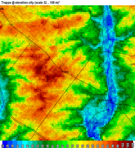
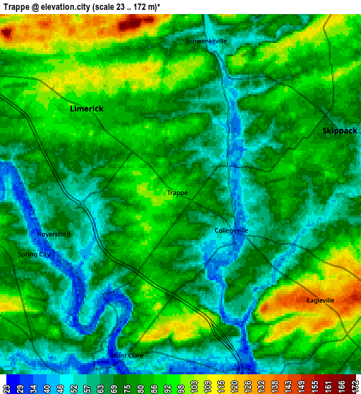
Below is the Elevation map of Trappe, which displays elevation range with different colors. Scale of the first map is from 32 to 108 m (105 to 354 ft) with average elevation of 71 meters (=233 ft) [note 1]
These maps also provides idea of topography and contour of this city, they are displayed at different zoom levels. More info about maps, scale and edge coordinates you can find below images.
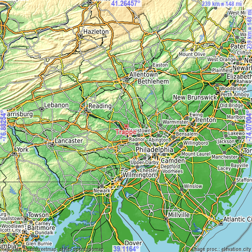
| \ | Map #1 | Map #2 | Topo.Map |
| Scale [m] | 32..108 m | 23..172 m | × |
| Scale [ft] | 105..354 ft | 75..564 ft | × |
| Average | 71 m = 233 ft | 77 m = 253 ft | × |
| Width | 7.46 km = 4.6 mi | 14.93 km = 9.3 mi | 238.9 km = 148.4 mi |
| Height | 7.46 km = 4.6 mi | 14.93 km = 9.3 mi | 238.8 km = 148.4 mi |
| ↑Max Latitude | 40.232547° | 40.266088° | 41.26457° |
| Latitude at center | 40.19899° | 40.19899° | 40.19899° |
| ↓Min Latitude | 40.165416° | 40.131825° | 39.1164° |
| ← Min Longitude | -75.520235° | -75.564181° | -76.88254° |
| Longitude center | -75.47629° | -75.47629° | -75.47629° |
| →Max Longitude | -75.432345° | -75.388399° | -74.07004° |
Nearby cities:
Cities around Trappe sort by population:
• Limerick elevation 90 m
5.3 km,  312°
312°
• Phoenixville 47 m
8.3 km,  203°
203°
• Audubon 64 m
8.8 km,  154°
154°
• Trooper 118 m
8.4 km,  130°
130°
• Collegeville 46 m
2.6 km, 125°
• Eagleville 135 m
7.3 km, 127°
• Royersford 66 m
5.5 km,  252°
252°
• Skippack 62 m
7.1 km,  68°
68°
• Spring City 55 m
6.5 km, 247°
• Spring Mount 53 m
8.7 km,  11°
11°
• Evansburg 69 m
4.5 km,  116°
116°
• Schwenksville 53 m
6.5 km, 9°
Multilingual:
 En español:
Trappe elevación 93 m.
 En France:
Trappe élévation 93 m.


Sources and notes:
- [note 1] Map square and city borders are not equal. Map elevation data is calculated only from area inside that square.
- [src 1] Elevation data from geonames database provided with same terms of usage.
- [src 2] The elevation map of Trappe is generated using elevation data from NASA's 3 arcsec (90m) resolution SRTM data.
- [src 3] Base (background) map © OpenStreetMap contributors tiles are generated by Geofabrik and OpenTopoMap.
Copyright & License:
This Trappe Elevation Map is licensed under CC BY-SA. You may reuse any part from this page, if you give a proper credit by linking to this URL:
 More info on terms of use page.