Throop elevation
Throop (Pennsylvania, Lackawanna County), United States elevation is 257 meters and Throop elevation in feet is 843 ft above sea level [src 1]. Throop is a populated place (feature code) with elevation that is 22 meters (72 ft) smaller than average city elevation in United States.
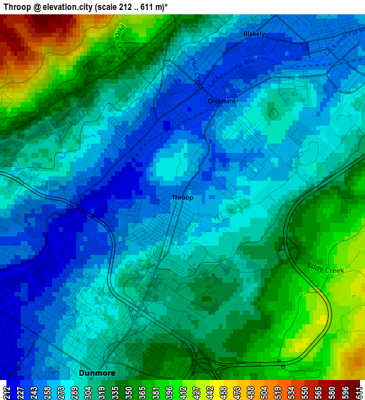
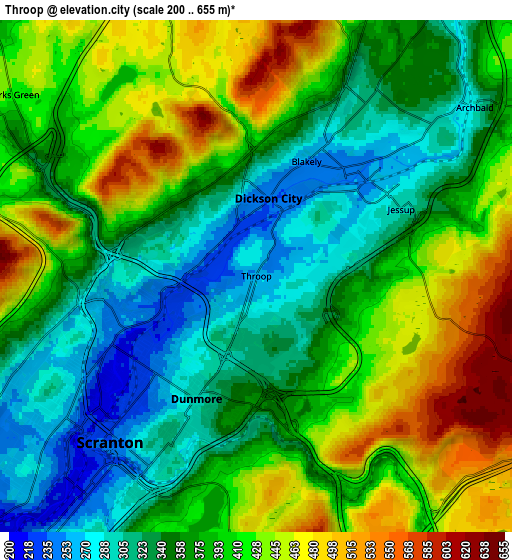
Below is the Elevation map of Throop, which displays elevation range with different colors. Scale of the first map is from 212 to 611 m (696 to 2005 ft) with average elevation of 308.8 meters (=1013 ft) [note 1]
These maps also provides idea of topography and contour of this city, they are displayed at different zoom levels. More info about maps, scale and edge coordinates you can find below images.
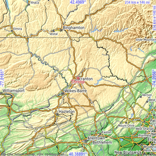
| \ | Map #1 | Map #2 | Topo.Map |
| Scale [m] | 212..611 m | 200..655 m | × |
| Scale [ft] | 696..2005 ft | 656..2149 ft | × |
| Average | 308.8 m = 1013 ft | 382.6 m = 1255 ft | × |
| Width | 7.32 km = 4.5 mi | 14.65 km = 9.1 mi | 234.4 km = 145.6 mi |
| Height | 7.32 km = 4.5 mi | 14.65 km = 9.1 mi | 234.4 km = 145.6 mi |
| ↑Max Latitude | 41.484399° | 41.517312° | 42.4969° |
| Latitude at center | 41.45147° | 41.45147° | 41.45147° |
| ↓Min Latitude | 41.418524° | 41.385561° | 40.38891° |
| ← Min Longitude | -75.655795° | -75.699741° | -77.0181° |
| Longitude center | -75.61185° | -75.61185° | -75.61185° |
| →Max Longitude | -75.567905° | -75.523959° | -74.2056° |
Nearby cities:
Cities around Throop sort by population:
• Scranton elevation 238 m
6.5 km,  223°
223°
• Dunmore 299 m
3.9 km,  205°
205°
• Archbald 289 m
7.9 km,  52°
52°
• Blakely 248 m
3.6 km,  23°
23°
• Taylor 223 m
10.1 km,  231°
231°
• Dickson City 237 m
2.3 km,  8°
8°
• Olyphant 238 m
2 km, 21°
• Clarks Summit 403 m
9.1 km,  297°
297°
• Jessup 296 m
4.6 km,  65°
65°
• Chinchilla 357 m
6 km, 295°
• Jermyn 296 m
10.4 km,  32°
32°
• Clarks Green 396 m
8.6 km, 302°
Multilingual:
 En español:
Throop elevación 257 m.
 En France:
Throop élévation 257 m.


Sources and notes:
- [note 1] Map square and city borders are not equal. Map elevation data is calculated only from area inside that square.
- [src 1] Elevation data from geonames database provided with same terms of usage.
- [src 2] The elevation map of Throop is generated using elevation data from NASA's 3 arcsec (90m) resolution SRTM data.
- [src 3] Base (background) map © OpenStreetMap contributors tiles are generated by Geofabrik and OpenTopoMap.
Copyright & License:
This Throop Elevation Map is licensed under CC BY-SA. You may reuse any part from this page, if you give a proper credit by linking to this URL:
 More info on terms of use page.