Steelton elevation
Steelton (Pennsylvania, Dauphin County), United States elevation is 94 meters and Steelton elevation in feet is 308 ft above sea level [src 1]. Steelton is a populated place (feature code) with elevation that is 185 meters (607 ft) smaller than average city elevation in United States.
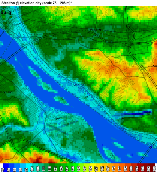
Below is the Elevation map of Steelton, which displays elevation range with different colors. Scale of the first map is from 75 to 208 m (246 to 682 ft) with average elevation of 118.4 meters (=388 ft) [note 1]
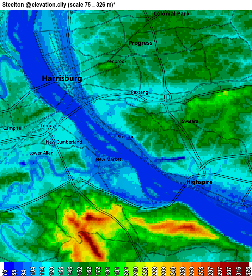
These maps also provides idea of topography and contour of this city, they are displayed at different zoom levels. More info about maps, scale and edge coordinates you can find below images.
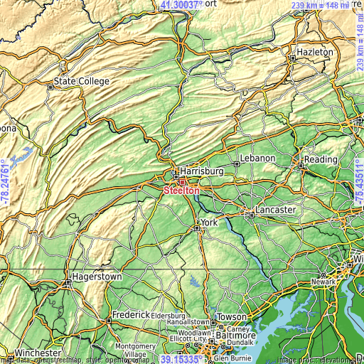
| \ | Map #1 | Map #2 | Topo.Map |
| Scale [m] | 75..208 m | 75..326 m | × |
| Scale [ft] | 246..682 ft | 246..1070 ft | × |
| Average | 118.4 m = 388 ft | 136.9 m = 449 ft | × |
| Width | 7.46 km = 4.6 mi | 14.92 km = 9.3 mi | 238.7 km = 148.3 mi |
| Height | 7.46 km = 4.6 mi | 14.92 km = 9.3 mi | 238.7 km = 148.3 mi |
| ↑Max Latitude | 40.268909° | 40.302432° | 41.30037° |
| Latitude at center | 40.23537° | 40.23537° | 40.23537° |
| ↓Min Latitude | 40.201814° | 40.168241° | 39.15335° |
| ← Min Longitude | -76.885305° | -76.929251° | -78.24761° |
| Longitude center | -76.84136° | -76.84136° | -76.84136° |
| →Max Longitude | -76.797415° | -76.753469° | -75.43511° |
Nearby cities:
Cities around Steelton sort by population:
• Harrisburg elevation 105 m
5.6 km,  319°
319°
• Progress 156 m
5.6 km,  8°
8°
• Camp Hill 132 m
6.7 km,  274°
274°
• New Cumberland 120 m
3.7 km,  264°
264°
• Lower Allen 117 m
5.1 km, 258°
• Lemoyne 116 m
4.5 km,  278°
278°
• Lawnton 121 m
4.1 km,  51°
51°
• Penbrook 151 m
4.5 km,  352°
352°
• Highspire 99 m
5.1 km,  122°
122°
• Paxtang 117 m
2.7 km,  16°
16°
• Bressler 151 m
1.9 km,  109°
109°
• Enhaut 149 m
1.3 km, 108°
Multilingual:
 En español:
Steelton elevación 94 m.
 En France:
Steelton élévation 94 m.


Sources and notes:
- [note 1] Map square and city borders are not equal. Map elevation data is calculated only from area inside that square.
- [src 1] Elevation data from geonames database provided with same terms of usage.
- [src 2] The elevation map of Steelton is generated using elevation data from NASA's 3 arcsec (90m) resolution SRTM data.
- [src 3] Base (background) map © OpenStreetMap contributors tiles are generated by Geofabrik and OpenTopoMap.
Copyright & License:
This Steelton Elevation Map is licensed under CC BY-SA. You may reuse any part from this page, if you give a proper credit by linking to this URL:
 More info on terms of use page.