Shippensburg elevation
Shippensburg (Pennsylvania, Cumberland County), United States elevation is 202 meters and Shippensburg elevation in feet is 663 ft above sea level [src 1]. Shippensburg is a populated place (feature code) with elevation that is 77 meters (253 ft) smaller than average city elevation in United States.
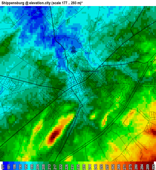
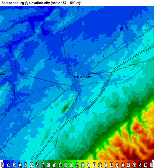
Below is the Elevation map of Shippensburg, which displays elevation range with different colors. Scale of the first map is from 177 to 293 m (581 to 961 ft) with average elevation of 214.4 meters (=703 ft) [note 1]
These maps also provides idea of topography and contour of this city, they are displayed at different zoom levels. More info about maps, scale and edge coordinates you can find below images.
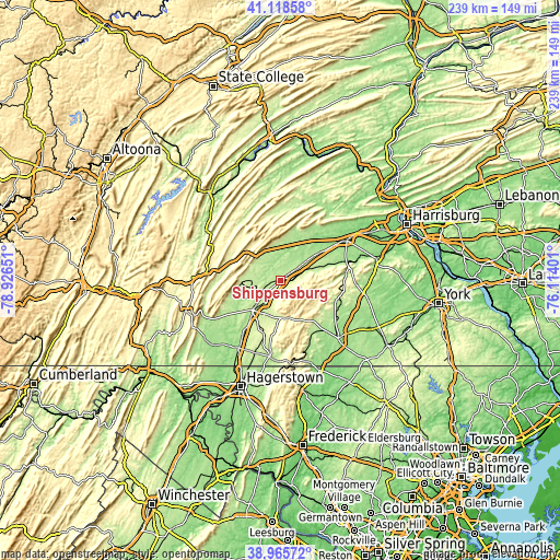
| \ | Map #1 | Map #2 | Topo.Map |
| Scale [m] | 177..293 m | 157..590 m | × |
| Scale [ft] | 581..961 ft | 515..1936 ft | × |
| Average | 214.4 m = 703 ft | 236.3 m = 775 ft | × |
| Width | 7.48 km = 4.6 mi | 14.96 km = 9.3 mi | 239.4 km = 148.8 mi |
| Height | 7.48 km = 4.6 mi | 14.96 km = 9.3 mi | 239.4 km = 148.8 mi |
| ↑Max Latitude | 40.084281° | 40.117895° | 41.11858° |
| Latitude at center | 40.05065° | 40.05065° | 40.05065° |
| ↓Min Latitude | 40.017003° | 39.983339° | 38.96572° |
| ← Min Longitude | -77.564205° | -77.608151° | -78.92651° |
| Longitude center | -77.52026° | -77.52026° | -77.52026° |
| →Max Longitude | -77.476315° | -77.432369° | -76.11401° |
Nearby cities:
Cities around Shippensburg sort by population:
• Chambersburg elevation 191 m
17.4 km,  223°
223°
• Carlisle 147 m
32.8 km,  59°
59°
• Waynesboro 218 m
33.1 km,  188°
188°
• Greencastle 179 m
33.9 km,  211°
211°
• Fayetteville 254 m
15.7 km, 189°
• Guilford 237 m
16.5 km,  204°
204°
• Mount Holly Springs 169 m
29.1 km,  74°
74°
• Guilford Siding 252 m
22 km, 200°
• Mont Alto 260 m
23.2 km, 188°
• Scotland 213 m
10.7 km, 212°
• Newville 157 m
17.1 km,  37°
37°
• Biglerville 195 m
26.8 km,  119°
119°
Multilingual:
 En español:
Shippensburg elevación 202 m.
 En France:
Shippensburg élévation 202 m.
 Auf Deutsch:
Shippensburg höhe über dem Meeresspiegel ist 202 m.

Sources and notes:
- [note 1] Map square and city borders are not equal. Map elevation data is calculated only from area inside that square.
- [src 1] Elevation data from geonames database provided with same terms of usage.
- [src 2] The elevation map of Shippensburg is generated using elevation data from NASA's 3 arcsec (90m) resolution SRTM data.
- [src 3] Base (background) map © OpenStreetMap contributors tiles are generated by Geofabrik and OpenTopoMap.
Copyright & License:
This Shippensburg Elevation Map is licensed under CC BY-SA. You may reuse any part from this page, if you give a proper credit by linking to this URL:
 More info on terms of use page.