Shenandoah elevation
Shenandoah (Pennsylvania, Schuylkill County), United States elevation is 396 meters and Shenandoah elevation in feet is 1299 ft above sea level [src 1]. Shenandoah is a populated place (feature code) with elevation that is 117 meters (384 ft) bigger than average city elevation in United States.
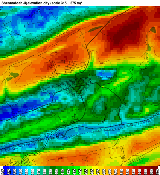
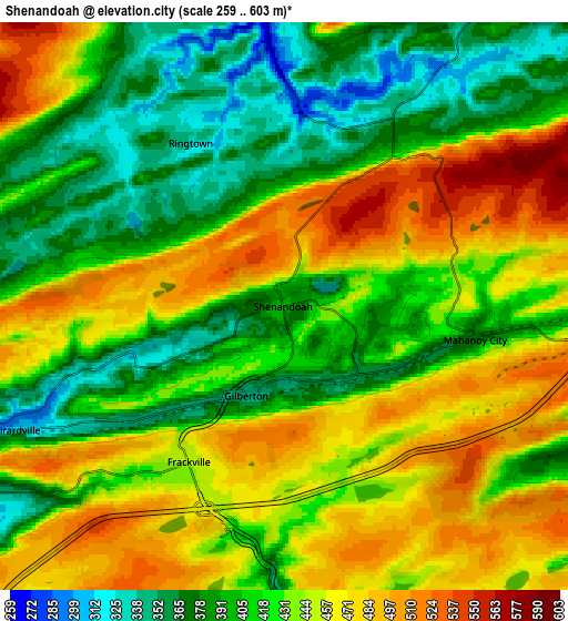
Below is the Elevation map of Shenandoah, which displays elevation range with different colors. Scale of the first map is from 315 to 575 m (1033 to 1886 ft) with average elevation of 435.5 meters (=1429 ft) [note 1]
These maps also provides idea of topography and contour of this city, they are displayed at different zoom levels. More info about maps, scale and edge coordinates you can find below images.
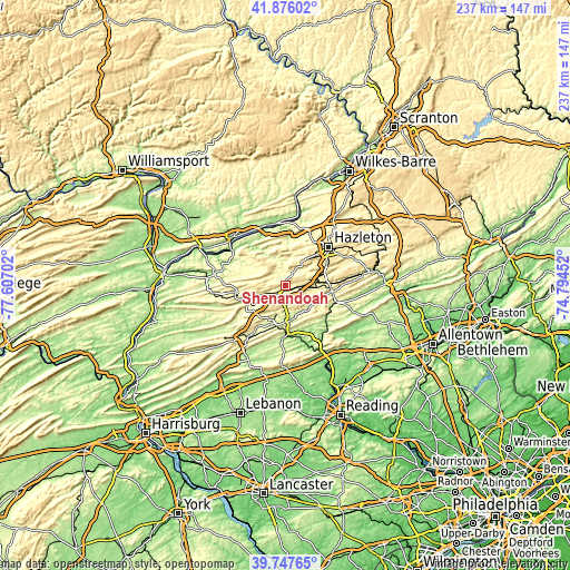
| \ | Map #1 | Map #2 | Topo.Map |
| Scale [m] | 315..575 m | 259..603 m | × |
| Scale [ft] | 1033..1886 ft | 850..1978 ft | × |
| Average | 435.5 m = 1429 ft | 430.7 m = 1413 ft | × |
| Width | 7.4 km = 4.6 mi | 14.79 km = 9.2 mi | 236.7 km = 147.1 mi |
| Height | 7.4 km = 4.6 mi | 14.79 km = 9.2 mi | 236.6 km = 147 mi |
| ↑Max Latitude | 40.853618° | 40.886849° | 41.87602° |
| Latitude at center | 40.82037° | 40.82037° | 40.82037° |
| ↓Min Latitude | 40.787105° | 40.753824° | 39.74765° |
| ← Min Longitude | -76.244715° | -76.288661° | -77.60702° |
| Longitude center | -76.20077° | -76.20077° | -76.20077° |
| →Max Longitude | -76.156825° | -76.112879° | -74.79452° |
Nearby cities:
Cities around Shenandoah sort by population:
• Pottsville elevation 197 m
15 km,  178°
178°
• Mount Carmel 338 m
18 km,  261°
261°
• Minersville 231 m
15.3 km,  199°
199°
• Mahanoy City 374 m
5.1 km,  99°
99°
• Frackville 456 m
4.7 km,  211°
211°
• Saint Clair 227 m
11.1 km, 175°
• Ashland 305 m
12.9 km,  250°
250°
• Port Carbon 205 m
14 km,  168°
168°
• Girardville 306 m
7.7 km, 245°
• Shenandoah Heights 507 m
1 km,  327°
327°
• New Philadelphia 213 m
13.3 km,  147°
147°
• Palo Alto 204 m
15 km, 170°
Multilingual:
 En español:
Shenandoah elevación 396 m.
 En France:
Shenandoah élévation 396 m.
 Auf Deutsch:
Shenandoah höhe über dem Meeresspiegel ist 396 m.

Sources and notes:
- [note 1] Map square and city borders are not equal. Map elevation data is calculated only from area inside that square.
- [src 1] Elevation data from geonames database provided with same terms of usage.
- [src 2] The elevation map of Shenandoah is generated using elevation data from NASA's 3 arcsec (90m) resolution SRTM data.
- [src 3] Base (background) map © OpenStreetMap contributors tiles are generated by Geofabrik and OpenTopoMap.
Copyright & License:
This Shenandoah Elevation Map is licensed under CC BY-SA. You may reuse any part from this page, if you give a proper credit by linking to this URL:
 More info on terms of use page.