Newmanstown elevation
Newmanstown (Pennsylvania, Lebanon County), United States elevation is 147 meters and Newmanstown elevation in feet is 482 ft above sea level [src 1]. Newmanstown is a populated place (feature code) with elevation that is 132 meters (433 ft) smaller than average city elevation in United States.
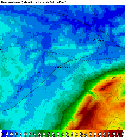
Below is the Elevation map of Newmanstown, which displays elevation range with different colors. Scale of the first map is from 102 to 419 m (335 to 1375 ft) with average elevation of 174.8 meters (=573 ft) [note 1]
These maps also provides idea of topography and contour of this city, they are displayed at different zoom levels. More info about maps, scale and edge coordinates you can find below images.
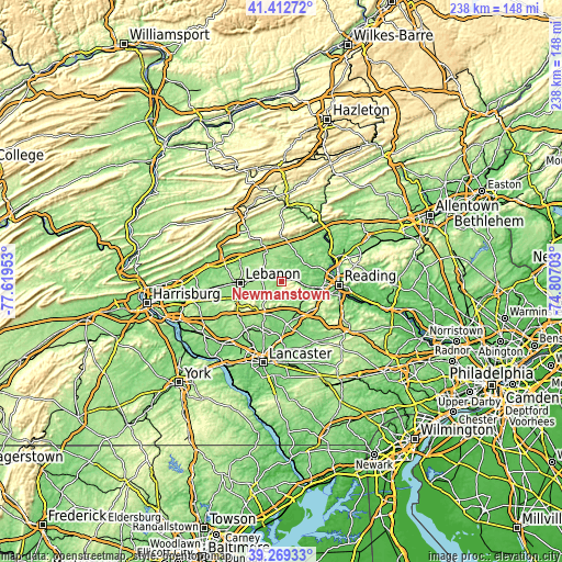
| \ | Map #1 | Topo.Map |
| Scale [m] | 102..419 m | × |
| Scale [ft] | 335..1375 ft | × |
| Average | 174.8 m = 573 ft | × |
| Width | 7.45 km = 4.6 mi | 238.3 km = 148.1 mi |
| Height | 7.45 km = 4.6 mi | 238.3 km = 148.1 mi |
| ↑Max Latitude | 40.383023° | 41.41272° |
| Latitude at center | 40.34954° | 40.34954° |
| ↓Min Latitude | 40.316041° | 39.26933° |
| ← Min Longitude | -76.257225° | -77.61953° |
| Longitude center | -76.21328° | -76.21328° |
| →Max Longitude | -76.169335° | -74.80703° |
Nearby cities:
Cities around Newmanstown sort by population:
• Denver elevation 128 m
14.5 km,  153°
153°
• Myerstown 149 m
8.1 km,  290°
290°
• Womelsdorf 124 m
2.8 km,  61°
61°
• Wernersville 112 m
11.5 km,  100°
100°
• Robesonia 130 m
6.7 km,  87°
87°
• Reinholds 141 m
12.4 km,  137°
137°
• Avon 153 m
15 km,  268°
268°
• Richland 150 m
4 km, 285°
• Clay 109 m
15 km,  193°
193°
• Brickerville 164 m
15.7 km,  208°
208°
• Hebron 154 m
15.8 km, 265°
• Schoeneck 174 m
12.5 km,  164°
164°
Multilingual:
 En español:
Newmanstown elevación 147 m.
 En France:
Newmanstown élévation 147 m.
 Auf Deutsch:
Newmanstown höhe über dem Meeresspiegel ist 147 m.

Sources and notes:
- [note 1] Map square and city borders are not equal. Map elevation data is calculated only from area inside that square.
- [src 1] Elevation data from geonames database provided with same terms of usage.
- [src 2] The elevation map of Newmanstown is generated using elevation data from NASA's 3 arcsec (90m) resolution SRTM data.
- [src 3] Base (background) map © OpenStreetMap contributors tiles are generated by Geofabrik and OpenTopoMap.
Copyright & License:
This Newmanstown Elevation Map is licensed under CC BY-SA. You may reuse any part from this page, if you give a proper credit by linking to this URL:
 More info on terms of use page.