Mount Pocono elevation
Mount Pocono (Pennsylvania, Monroe County), United States elevation is 564 meters and Mount Pocono elevation in feet is 1850 ft above sea level [src 1]. Mount Pocono is a populated place (feature code) with elevation that is 285 meters (935 ft) bigger than average city elevation in United States.
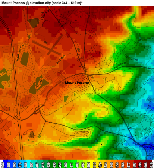
Below is the Elevation map of Mount Pocono, which displays elevation range with different colors. Scale of the first map is from 344 to 619 m (1129 to 2031 ft) with average elevation of 524 meters (=1719 ft) [note 1]
These maps also provides idea of topography and contour of this city, they are displayed at different zoom levels. More info about maps, scale and edge coordinates you can find below images.
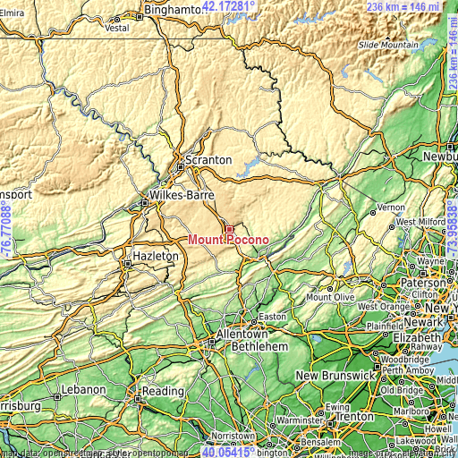
| \ | Map #1 | Topo.Map |
| Scale [m] | 344..619 m | × |
| Scale [ft] | 1129..2031 ft | × |
| Average | 524 m = 1719 ft | × |
| Width | 7.36 km = 4.6 mi | 235.6 km = 146.4 mi |
| Height | 7.36 km = 4.6 mi | 235.6 km = 146.4 mi |
| ↑Max Latitude | 41.155126° | 42.17281° |
| Latitude at center | 41.12203° | 41.12203° |
| ↓Min Latitude | 41.088917° | 40.05415° |
| ← Min Longitude | -75.408575° | -76.77088° |
| Longitude center | -75.36463° | -75.36463° |
| →Max Longitude | -75.320685° | -73.95838° |
Nearby cities:
Cities around Mount Pocono sort by population:
• Arlington Heights elevation 154 m
19.2 km,  139°
139°
• Sierra View 579 m
14.6 km,  212°
212°
• Penn Estates 271 m
14.1 km,  131°
131°
• Indian Mountain Lake 548 m
17.9 km,  222°
222°
• Emerald Lakes 615 m
5.9 km,  230°
230°
• Tannersville 274 m
10.4 km,  151°
151°
• Sun Valley 363 m
17.7 km, 208°
• Sun Valley 578 m
15.1 km, 215°
• Parkside 222 m
9.8 km,  103°
103°
• Pocono Pines 558 m
7.7 km,  257°
257°
• Big Bass Lake 588 m
17.4 km,  327°
327°
• Mountainhome 378 m
9.7 km,  53°
53°
Multilingual:
 En español:
Mount Pocono elevación 564 m.
 En France:
Mount Pocono élévation 564 m.
 Auf Deutsch:
Mount Pocono höhe über dem Meeresspiegel ist 564 m.

Sources and notes:
- [note 1] Map square and city borders are not equal. Map elevation data is calculated only from area inside that square.
- [src 1] Elevation data from geonames database provided with same terms of usage.
- [src 2] The elevation map of Mount Pocono is generated using elevation data from NASA's 3 arcsec (90m) resolution SRTM data.
- [src 3] Base (background) map © OpenStreetMap contributors tiles are generated by Geofabrik and OpenTopoMap.
Copyright & License:
This Mount Pocono Elevation Map is licensed under CC BY-SA. You may reuse any part from this page, if you give a proper credit by linking to this URL:
 More info on terms of use page.