Latrobe elevation
Latrobe (Pennsylvania, Westmoreland County), United States elevation is 309 meters and Latrobe elevation in feet is 1014 ft above sea level [src 1]. Latrobe is a populated place (feature code) with elevation that is 30 meters (98 ft) bigger than average city elevation in United States.
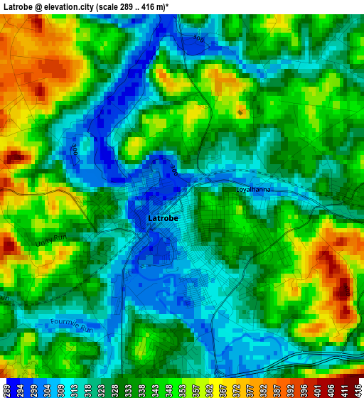
Below is the Elevation map of Latrobe, which displays elevation range with different colors. Scale of the first map is from 289 to 416 m (948 to 1365 ft) with average elevation of 333.8 meters (=1095 ft) [note 1]
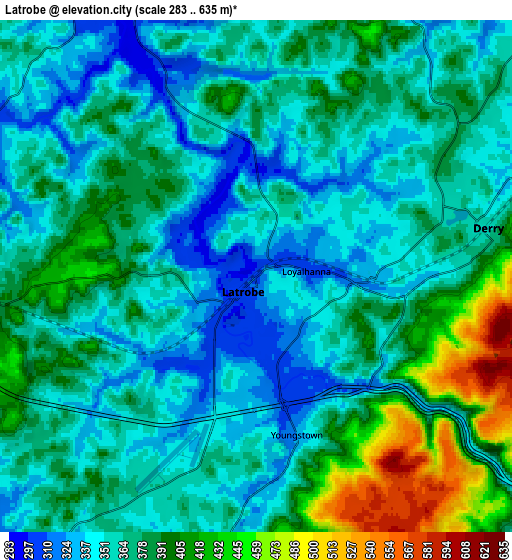
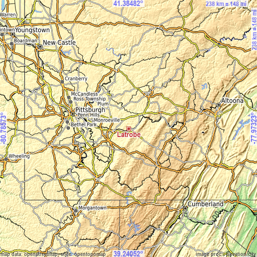
These maps also provides idea of topography and contour of this city, they are displayed at different zoom levels. More info about maps, scale and edge coordinates you can find below images.
| \ | Map #1 | Map #2 | Topo.Map |
| Scale [m] | 289..416 m | 283..635 m | × |
| Scale [ft] | 948..1365 ft | 928..2083 ft | × |
| Average | 333.8 m = 1095 ft | 372.1 m = 1221 ft | × |
| Width | 7.45 km = 4.6 mi | 14.9 km = 9.3 mi | 238.4 km = 148.1 mi |
| Height | 7.45 km = 4.6 mi | 14.9 km = 9.3 mi | 238.4 km = 148.1 mi |
| ↑Max Latitude | 40.354677° | 40.388157° | 41.38482° |
| Latitude at center | 40.32118° | 40.32118° | 40.32118° |
| ↓Min Latitude | 40.287666° | 40.254136° | 39.24052° |
| ← Min Longitude | -79.423425° | -79.467371° | -80.78573° |
| Longitude center | -79.37948° | -79.37948° | -79.37948° |
| →Max Longitude | -79.335535° | -79.291589° | -77.97323° |
Nearby cities:
Cities around Latrobe sort by population:
• Greensburg elevation 308 m
13.7 km,  260°
260°
• Loyalhanna 301 m
1.5 km,  83°
83°
• Blairsville 309 m
15.8 km,  39°
39°
• Youngwood 291 m
19 km,  241°
241°
• Delmont 382 m
19.1 km,  302°
302°
• Derry 358 m
6.9 km, 78°
• Lawson Heights 352 m
3.4 km,  194°
194°
• Southwest Greensburg 329 m
14.6 km, 256°
• South Greensburg 325 m
14.8 km,  251°
251°
• Ligonier 368 m
14.8 km,  125°
125°
• Waterford 405 m
19.4 km,  112°
112°
• Calumet 305 m
15.2 km,  216°
216°
Multilingual:
 En español:
Latrobe elevación 309 m.
 En France:
Latrobe élévation 309 m.


Sources and notes:
- [note 1] Map square and city borders are not equal. Map elevation data is calculated only from area inside that square.
- [src 1] Elevation data from geonames database provided with same terms of usage.
- [src 2] The elevation map of Latrobe is generated using elevation data from NASA's 3 arcsec (90m) resolution SRTM data.
- [src 3] Base (background) map © OpenStreetMap contributors tiles are generated by Geofabrik and OpenTopoMap.
Copyright & License:
This Latrobe Elevation Map is licensed under CC BY-SA. You may reuse any part from this page, if you give a proper credit by linking to this URL:
 More info on terms of use page.