Houston elevation
Houston (Pennsylvania, Washington County), United States elevation is 301 meters and Houston elevation in feet is 988 ft above sea level [src 1]. Houston is a populated place (feature code) with elevation that is 22 meters (72 ft) bigger than average city elevation in United States.
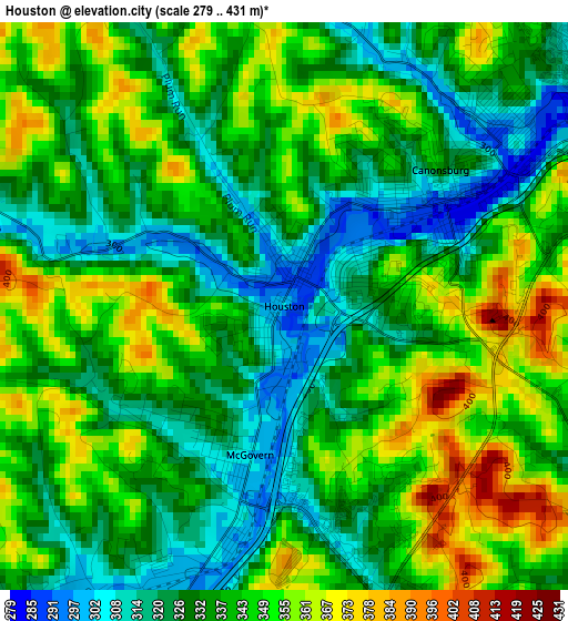
Below is the Elevation map of Houston, which displays elevation range with different colors. Scale of the first map is from 279 to 431 m (915 to 1414 ft) with average elevation of 338.5 meters (=1111 ft) [note 1]
These maps also provides idea of topography and contour of this city, they are displayed at different zoom levels. More info about maps, scale and edge coordinates you can find below images.
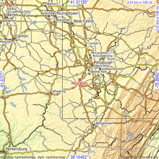
| \ | Map #1 | Topo.Map |
| Scale [m] | 279..431 m | × |
| Scale [ft] | 915..1414 ft | × |
| Average | 338.5 m = 1111 ft | × |
| Width | 7.46 km = 4.6 mi | 238.7 km = 148.3 mi |
| Height | 7.46 km = 4.6 mi | 238.7 km = 148.3 mi |
| ↑Max Latitude | 40.279994° | 41.31128° |
| Latitude at center | 40.24646° | 40.24646° |
| ↓Min Latitude | 40.212909° | 39.16462° |
| ← Min Longitude | -80.255395° | -81.6177° |
| Longitude center | -80.21145° | -80.21145° |
| →Max Longitude | -80.167505° | -78.8052° |
Nearby cities:
Cities around Houston sort by population:
• Washington elevation 359 m
8.6 km,  200°
200°
• Canonsburg 336 m
2.7 km,  48°
48°
• Bryn Mawr 352 m
12.4 km,  58°
58°
• McMurray 310 m
11.4 km,  72°
72°
• Thompsonville 289 m
10.1 km, 60°
• Midland 304 m
1.5 km,  337°
337°
• Wolfdale 319 m
8.8 km,  227°
227°
• McGovern 303 m
2 km,  192°
192°
• Muse 323 m
5.2 km,  10°
10°
• Cecil-Bishop 347 m
8.1 km, 10°
• McDonald 301 m
14 km,  351°
351°
• East Washington 345 m
8.4 km, 195°
Multilingual:
 En español:
Houston elevación 301 m.
 En France:
Houston élévation 301 m.


Sources and notes:
- [note 1] Map square and city borders are not equal. Map elevation data is calculated only from area inside that square.
- [src 1] Elevation data from geonames database provided with same terms of usage.
- [src 2] The elevation map of Houston is generated using elevation data from NASA's 3 arcsec (90m) resolution SRTM data.
- [src 3] Base (background) map © OpenStreetMap contributors tiles are generated by Geofabrik and OpenTopoMap.
Copyright & License:
This Houston Elevation Map is licensed under CC BY-SA. You may reuse any part from this page, if you give a proper credit by linking to this URL:
 More info on terms of use page.