Geistown elevation
Geistown (Pennsylvania, Cambria County), United States elevation is 578 meters and Geistown elevation in feet is 1896 ft above sea level [src 1]. Geistown is a populated place (feature code) with elevation that is 299 meters (981 ft) bigger than average city elevation in United States.
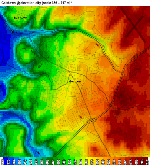
Below is the Elevation map of Geistown, which displays elevation range with different colors. Scale of the first map is from 356 to 717 m (1168 to 2352 ft) with average elevation of 567.8 meters (=1863 ft) [note 1]
These maps also provides idea of topography and contour of this city, they are displayed at different zoom levels. More info about maps, scale and edge coordinates you can find below images.
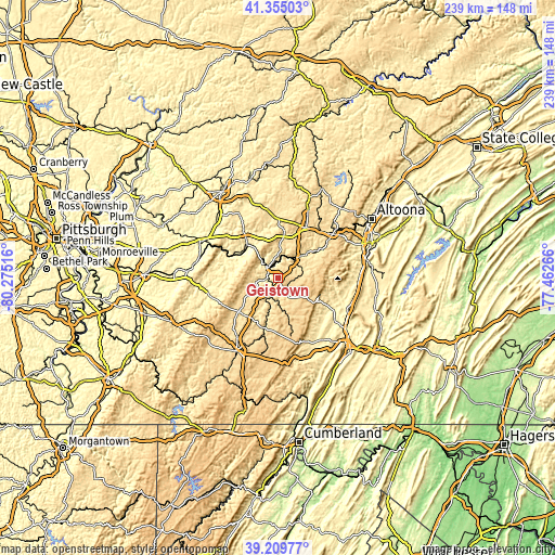
| \ | Map #1 | Topo.Map |
| Scale [m] | 356..717 m | × |
| Scale [ft] | 1168..2352 ft | × |
| Average | 567.8 m = 1863 ft | × |
| Width | 7.45 km = 4.6 mi | 238.5 km = 148.2 mi |
| Height | 7.45 km = 4.6 mi | 238.5 km = 148.2 mi |
| ↑Max Latitude | 40.324422° | 41.35503° |
| Latitude at center | 40.29091° | 40.29091° |
| ↓Min Latitude | 40.257381° | 39.20977° |
| ← Min Longitude | -78.912855° | -80.27516° |
| Longitude center | -78.86891° | -78.86891° |
| →Max Longitude | -78.824965° | -77.46266° |
Nearby cities:
Cities around Geistown sort by population:
• Johnstown elevation 359 m
6 km,  311°
311°
• Westmont 538 m
7.5 km,  291°
291°
• Windber 543 m
6.4 km,  153°
153°
• Elim 506 m
6.3 km,  277°
277°
• Belmont 523 m
1.8 km,  257°
257°
• Southmont 492 m
6.3 km, 290°
• Oakland 488 m
2.3 km,  317°
317°
• Ferndale 366 m
3.9 km,  266°
266°
• Conemaugh 370 m
5.2 km, 320°
• Dale 390 m
3.9 km, 309°
• East Conemaugh 392 m
6.5 km,  348°
348°
• Salix 627 m
8.8 km,  83°
83°
Multilingual:
 En español:
Geistown elevación 578 m.
 En France:
Geistown élévation 578 m.
 Auf Deutsch:
Geistown höhe über dem Meeresspiegel ist 578 m.

Sources and notes:
- [note 1] Map square and city borders are not equal. Map elevation data is calculated only from area inside that square.
- [src 1] Elevation data from geonames database provided with same terms of usage.
- [src 2] The elevation map of Geistown is generated using elevation data from NASA's 3 arcsec (90m) resolution SRTM data.
- [src 3] Base (background) map © OpenStreetMap contributors tiles are generated by Geofabrik and OpenTopoMap.
Copyright & License:
This Geistown Elevation Map is licensed under CC BY-SA. You may reuse any part from this page, if you give a proper credit by linking to this URL:
 More info on terms of use page.