Erie elevation
Erie (Pennsylvania, Erie County), United States elevation is 201 meters and Erie elevation in feet is 659 ft above sea level [src 1]. Erie is a seat of a second-order administrative division (feature code) with elevation that is 78 meters (256 ft) smaller than average city elevation in United States.
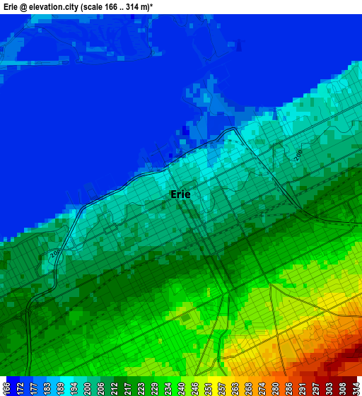
Below is the Elevation map of Erie, which displays elevation range with different colors. Scale of the first map is from 166 to 314 m (545 to 1030 ft) with average elevation of 202.4 meters (=664 ft) [note 1]
These maps also provides idea of topography and contour of this city, they are displayed at different zoom levels. More info about maps, scale and edge coordinates you can find below images.
| \ | Map #1 | Map #2 | Topo.Map |
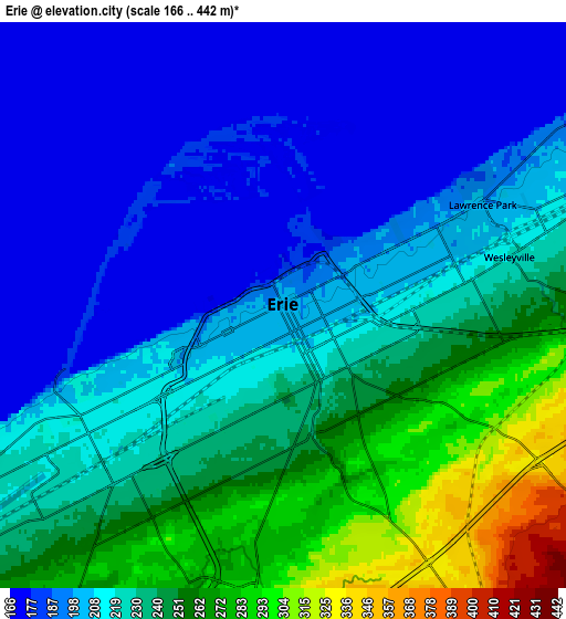
| Scale [m] | 166..314 m | 166..442 m | × |
| Scale [ft] | 545..1030 ft | 545..1450 ft | × |
| Average | 202.4 m = 664 ft | 220.7 m = 724 ft | × |
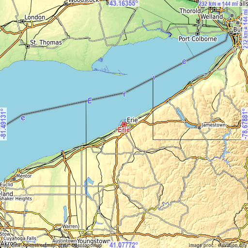
| Width | 7.25 km = 4.5 mi | 14.5 km = 9 mi | 231.9 km = 144.1 mi |
| Height | 7.25 km = 4.5 mi | 14.5 km = 9 mi | 231.9 km = 144.1 mi |
| ↑Max Latitude | 42.161803° | 42.194369° | 43.16355° |
| Latitude at center | 42.12922° | 42.12922° | 42.12922° |
| ↓Min Latitude | 42.09662° | 42.064004° | 41.07772° |
| ← Min Longitude | -80.129005° | -80.172951° | -81.49131° |
| Longitude center | -80.08506° | -80.08506° | -80.08506° |
| →Max Longitude | -80.041115° | -79.997169° | -78.67881° |
Nearby cities:
Cities around Erie sort by population:
• Northwest Harborcreek elevation 221 m
7.8 km,  73°
73°
• Edinboro 371 m
28.6 km,  187°
187°
• North East 244 m
22.8 km, 65°
• Lawrence Park 198 m
5.7 km,  63°
63°
• Wesleyville 221 m
5.9 km,  77°
77°
• Union City 386 m
32.3 km,  142°
142°
• Girard 237 m
24 km,  233°
233°
• Lake City 222 m
25 km,  239°
239°
• Fairview 243 m
17.8 km, 232°
• Waterford 372 m
22.3 km,  158°
158°
• Albion 273 m
35.3 km,  221°
221°
• Avonia 205 m
17.9 km, 238°
Multilingual:
 En español:
Erie elevación 201 m.
 En France:
Érié élévation 201 m.


Sources and notes:
- [note 1] Map square and city borders are not equal. Map elevation data is calculated only from area inside that square.
- [src 1] Elevation data from geonames database provided with same terms of usage.
- [src 2] The elevation map of Erie is generated using elevation data from NASA's 3 arcsec (90m) resolution SRTM data.
- [src 3] Base (background) map © OpenStreetMap contributors tiles are generated by Geofabrik and OpenTopoMap.
Copyright & License:
This Erie Elevation Map is licensed under CC BY-SA. You may reuse any part from this page, if you give a proper credit by linking to this URL:
 More info on terms of use page.