Boiling Springs elevation
Boiling Springs (Pennsylvania, Cumberland County), United States elevation is 148 meters and Boiling Springs elevation in feet is 486 ft above sea level [src 1]. Boiling Springs is a populated place (feature code) with elevation that is 131 meters (430 ft) smaller than average city elevation in United States.
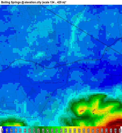
Below is the Elevation map of Boiling Springs, which displays elevation range with different colors. Scale of the first map is from 134 to 429 m (440 to 1407 ft) with average elevation of 175.3 meters (=575 ft) [note 1]
These maps also provides idea of topography and contour of this city, they are displayed at different zoom levels. More info about maps, scale and edge coordinates you can find below images.
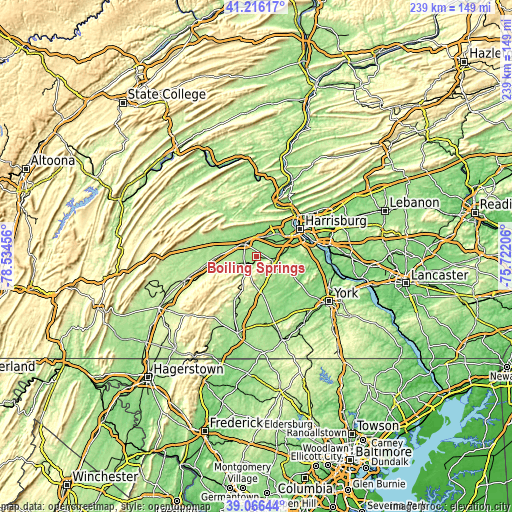
| \ | Map #1 | Topo.Map |
| Scale [m] | 134..429 m | × |
| Scale [ft] | 440..1407 ft | × |
| Average | 175.3 m = 575 ft | × |
| Width | 7.47 km = 4.6 mi | 239 km = 148.5 mi |
| Height | 7.47 km = 4.6 mi | 239 km = 148.5 mi |
| ↑Max Latitude | 40.183392° | 41.21617° |
| Latitude at center | 40.14981° | 40.14981° |
| ↓Min Latitude | 40.116212° | 39.06644° |
| ← Min Longitude | -77.172255° | -78.53456° |
| Longitude center | -77.12831° | -77.12831° |
| →Max Longitude | -77.084365° | -75.72206° |
Nearby cities:
Cities around Boiling Springs sort by population:
• Carlisle elevation 147 m
7.7 km,  318°
318°
• Mechanicsburg 132 m
12.4 km,  54°
54°
• Camp Hill 132 m
20.3 km,  60°
60°
• New Cumberland 120 m
22.6 km,  66°
66°
• Lower Allen 117 m
21.1 km, 66°
• Schlusser 126 m
11 km,  338°
338°
• Lemoyne 116 m
22.3 km, 62°
• Wormleysburg 138 m
22.1 km, 55°
• Dillsburg 176 m
9 km,  118°
118°
• Lake Meade 158 m
19.9 km,  157°
157°
• Mount Holly Springs 169 m
6.3 km,  236°
236°
• Shiremanstown 127 m
16.9 km, 61°
Multilingual:
 En español:
Boiling Springs elevación 148 m.
 En France:
Boiling Springs élévation 148 m.
 Auf Deutsch:
Boiling Springs höhe über dem Meeresspiegel ist 148 m.

Sources and notes:
- [note 1] Map square and city borders are not equal. Map elevation data is calculated only from area inside that square.
- [src 1] Elevation data from geonames database provided with same terms of usage.
- [src 2] The elevation map of Boiling Springs is generated using elevation data from NASA's 3 arcsec (90m) resolution SRTM data.
- [src 3] Base (background) map © OpenStreetMap contributors tiles are generated by Geofabrik and OpenTopoMap.
Copyright & License:
This Boiling Springs Elevation Map is licensed under CC BY-SA. You may reuse any part from this page, if you give a proper credit by linking to this URL:
 More info on terms of use page.