Ashley elevation
Ashley (Pennsylvania, Luzerne County), United States elevation is 218 meters and Ashley elevation in feet is 715 ft above sea level [src 1]. Ashley is a populated place (feature code) with elevation that is 61 meters (200 ft) smaller than average city elevation in United States.
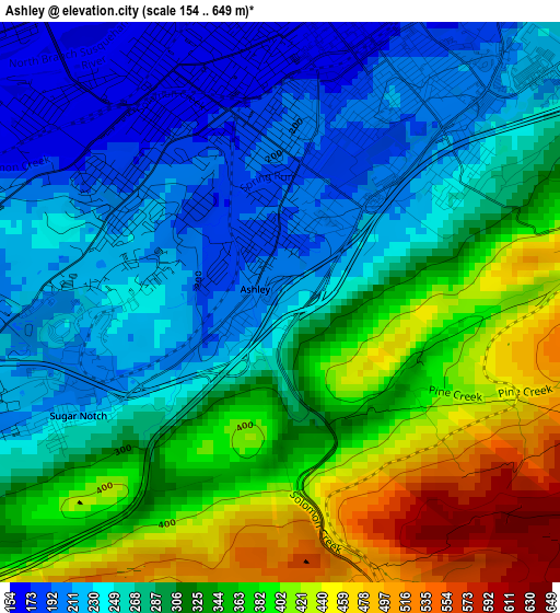
Below is the Elevation map of Ashley, which displays elevation range with different colors. Scale of the first map is from 154 to 649 m (505 to 2129 ft) with average elevation of 306 meters (=1004 ft) [note 1]
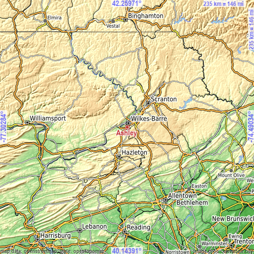
These maps also provides idea of topography and contour of this city, they are displayed at different zoom levels. More info about maps, scale and edge coordinates you can find below images.
| \ | Map #1 | Topo.Map |
| Scale [m] | 154..649 m | × |
| Scale [ft] | 505..2129 ft | × |
| Average | 306 m = 1004 ft | × |
| Width | 7.35 km = 4.6 mi | 235.3 km = 146.2 mi |
| Height | 7.35 km = 4.6 mi | 235.2 km = 146.1 mi |
| ↑Max Latitude | 41.243412° | 42.25971° |
| Latitude at center | 41.21036° | 41.21036° |
| ↓Min Latitude | 41.177292° | 40.14391° |
| ← Min Longitude | -75.940535° | -77.30284° |
| Longitude center | -75.89659° | -75.89659° |
| →Max Longitude | -75.852645° | -74.49034° |
Nearby cities:
Cities around Ashley sort by population:
• Wilkes-Barre elevation 172 m
4.2 km,  17°
17°
• Kingston 166 m
5.7 km,  359°
359°
• Mountain Top 480 m
4.8 km,  160°
160°
• Nanticoke 175 m
9.1 km,  266°
266°
• Plymouth 164 m
5.2 km,  309°
309°
• Edwardsville 216 m
6.8 km,  345°
345°
• Larksville 170 m
4.8 km,  323°
323°
• Plains 199 m
8.2 km,  28°
28°
• Forty Fort 168 m
7.8 km,  11°
11°
• Luzerne 190 m
8.4 km, 357°
• Georgetown 212 m
3 km,  50°
50°
• Hudson 196 m
8.8 km,  35°
35°
Multilingual:
 En español:
Ashley elevación 218 m.
 En France:
Ashley élévation 218 m.


Sources and notes:
- [note 1] Map square and city borders are not equal. Map elevation data is calculated only from area inside that square.
- [src 1] Elevation data from geonames database provided with same terms of usage.
- [src 2] The elevation map of Ashley is generated using elevation data from NASA's 3 arcsec (90m) resolution SRTM data.
- [src 3] Base (background) map © OpenStreetMap contributors tiles are generated by Geofabrik and OpenTopoMap.
Copyright & License:
This Ashley Elevation Map is licensed under CC BY-SA. You may reuse any part from this page, if you give a proper credit by linking to this URL:
 More info on terms of use page.