Woodville elevation
Woodville (Ohio, Sandusky County), United States elevation is 194 meters and Woodville elevation in feet is 636 ft above sea level [src 1]. Woodville is a populated place (feature code) with elevation that is 85 meters (279 ft) smaller than average city elevation in United States.
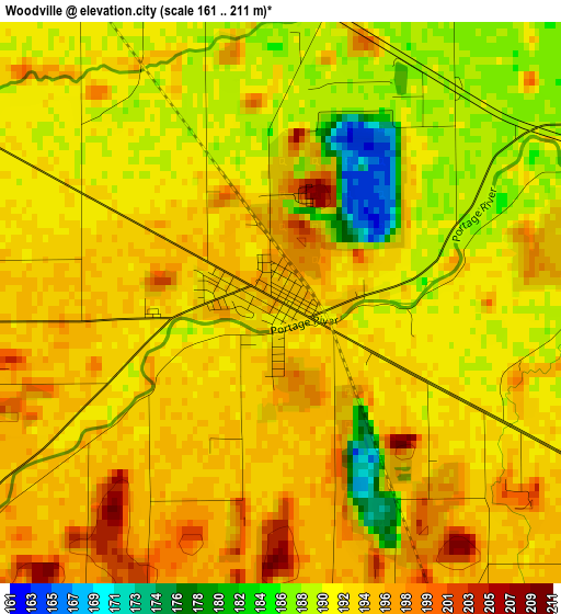
Below is the Elevation map of Woodville, which displays elevation range with different colors. Scale of the first map is from 161 to 211 m (528 to 692 ft) with average elevation of 191.8 meters (=629 ft) [note 1]
These maps also provides idea of topography and contour of this city, they are displayed at different zoom levels. More info about maps, scale and edge coordinates you can find below images.
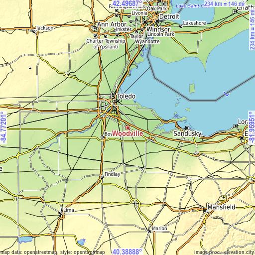
| \ | Map #1 | Topo.Map |
| Scale [m] | 161..211 m | × |
| Scale [ft] | 528..692 ft | × |
| Average | 191.8 m = 629 ft | × |
| Width | 7.32 km = 4.5 mi | 234.4 km = 145.6 mi |
| Height | 7.32 km = 4.5 mi | 234.4 km = 145.6 mi |
| ↑Max Latitude | 41.484369° | 42.49687° |
| Latitude at center | 41.45144° | 41.45144° |
| ↓Min Latitude | 41.418494° | 40.38888° |
| ← Min Longitude | -83.409705° | -84.77201° |
| Longitude center | -83.36576° | -83.36576° |
| →Max Longitude | -83.321815° | -81.95951° |
Nearby cities:
Cities around Woodville sort by population:
• Northwood elevation 186 m
19.3 km,  333°
333°
• Walbridge 187 m
18.5 km, 325°
• Oak Harbor 176 m
19.3 km,  71°
71°
• Gibsonburg 208 m
8.3 km,  153°
153°
• Genoa 191 m
7.4 km,  4°
4°
• Curtice 181 m
18.6 km,  359°
359°
• Pemberville 200 m
9.1 km,  240°
240°
• Elmore 188 m
6.4 km,  64°
64°
• Stony Prairie 190 m
20.8 km,  122°
122°
• Millbury 188 m
13.7 km,  338°
338°
• Luckey 205 m
10.1 km,  269°
269°
• Bradner 210 m
15.4 km,  203°
203°
Multilingual:
 En español:
Woodville elevación 194 m.
 En France:
Woodville élévation 194 m.
 Auf Deutsch:
Woodville höhe über dem Meeresspiegel ist 194 m.

Sources and notes:
- [note 1] Map square and city borders are not equal. Map elevation data is calculated only from area inside that square.
- [src 1] Elevation data from geonames database provided with same terms of usage.
- [src 2] The elevation map of Woodville is generated using elevation data from NASA's 3 arcsec (90m) resolution SRTM data.
- [src 3] Base (background) map © OpenStreetMap contributors tiles are generated by Geofabrik and OpenTopoMap.
Copyright & License:
This Woodville Elevation Map is licensed under CC BY-SA. You may reuse any part from this page, if you give a proper credit by linking to this URL:
 More info on terms of use page.