Wakeman elevation
Wakeman (Ohio, Huron County), United States elevation is 260 meters and Wakeman elevation in feet is 853 ft above sea level [src 1]. Wakeman is a populated place (feature code) with elevation that is 19 meters (62 ft) smaller than average city elevation in United States.
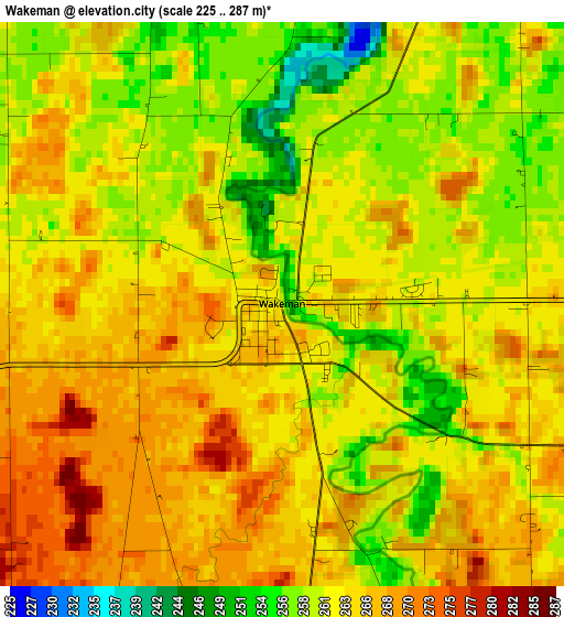
Below is the Elevation map of Wakeman, which displays elevation range with different colors. Scale of the first map is from 225 to 287 m (738 to 942 ft) with average elevation of 262.7 meters (=862 ft) [note 1]
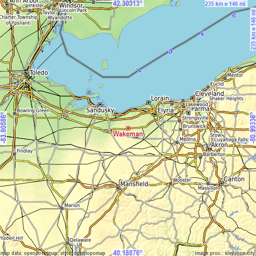
These maps also provides idea of topography and contour of this city, they are displayed at different zoom levels. More info about maps, scale and edge coordinates you can find below images.
| \ | Map #1 | Topo.Map |
| Scale [m] | 225..287 m | × |
| Scale [ft] | 738..942 ft | × |
| Average | 262.7 m = 862 ft | × |
| Width | 7.35 km = 4.6 mi | 235.1 km = 146.1 mi |
| Height | 7.35 km = 4.6 mi | 235.1 km = 146.1 mi |
| ↑Max Latitude | 41.287529° | 42.30313° |
| Latitude at center | 41.2545° | 41.2545° |
| ↓Min Latitude | 41.221454° | 40.18876° |
| ← Min Longitude | -82.443555° | -83.80586° |
| Longitude center | -82.39961° | -82.39961° |
| →Max Longitude | -82.355665° | -80.99336° |
Nearby cities:
Cities around Wakeman sort by population:
• Norwalk elevation 223 m
18.1 km,  265°
265°
• Amherst 212 m
21.7 km,  42°
42°
• Vermilion-on-the-Lake 188 m
20.3 km,  18°
18°
• Vermilion 183 m
18.9 km,  8°
8°
• Oberlin 251 m
15.8 km,  73°
73°
• Huron 177 m
20.3 km,  320°
320°
• Wellington 261 m
17.9 km,  122°
122°
• New London 299 m
18.8 km,  180°
180°
• Camden 265 m
8.1 km,  103°
103°
• Lagrange 251 m
23.5 km,  94°
94°
• South Amherst 243 m
16.6 km,  47°
47°
• Milan 202 m
17.9 km,  285°
285°
Multilingual:
 En español:
Wakeman elevación 260 m.
 En France:
Wakeman élévation 260 m.


Sources and notes:
- [note 1] Map square and city borders are not equal. Map elevation data is calculated only from area inside that square.
- [src 1] Elevation data from geonames database provided with same terms of usage.
- [src 2] The elevation map of Wakeman is generated using elevation data from NASA's 3 arcsec (90m) resolution SRTM data.
- [src 3] Base (background) map © OpenStreetMap contributors tiles are generated by Geofabrik and OpenTopoMap.
Copyright & License:
This Wakeman Elevation Map is licensed under CC BY-SA. You may reuse any part from this page, if you give a proper credit by linking to this URL:
 More info on terms of use page.