University Heights elevation
University Heights (Ohio, Cuyahoga County), United States elevation is 315 meters and University Heights elevation in feet is 1033 ft above sea level [src 1]. University Heights is a populated place (feature code) with elevation that is 36 meters (118 ft) bigger than average city elevation in United States.
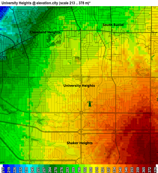
Below is the Elevation map of University Heights, which displays elevation range with different colors. Scale of the first map is from 213 to 378 m (699 to 1240 ft) with average elevation of 309.4 meters (=1015 ft) [note 1]
These maps also provides idea of topography and contour of this city, they are displayed at different zoom levels. More info about maps, scale and edge coordinates you can find below images.
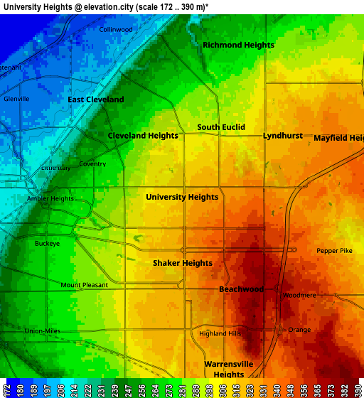
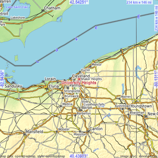
| \ | Map #1 | Map #2 | Topo.Map |
| Scale [m] | 213..378 m | 172..390 m | × |
| Scale [ft] | 699..1240 ft | 564..1280 ft | × |
| Average | 309.4 m = 1015 ft | 289.8 m = 951 ft | × |
| Width | 7.32 km = 4.5 mi | 14.64 km = 9.1 mi | 234.2 km = 145.5 mi |
| Height | 7.32 km = 4.5 mi | 14.64 km = 9.1 mi | 234.2 km = 145.5 mi |
| ↑Max Latitude | 41.530736° | 41.563625° | 42.54251° |
| Latitude at center | 41.49783° | 41.49783° | 41.49783° |
| ↓Min Latitude | 41.464907° | 41.431968° | 40.43603° |
| ← Min Longitude | -81.581295° | -81.625241° | -82.9436° |
| Longitude center | -81.53735° | -81.53735° | -81.53735° |
| →Max Longitude | -81.493405° | -81.449459° | -80.1311° |
Nearby cities:
Cities around University Heights sort by population:
• Cleveland Heights elevation 288 m
2.9 km,  327°
327°
• Shaker Heights 320 m
2.7 km,  179°
179°
• South Euclid 291 m
3.2 km,  29°
29°
• Mayfield Heights 331 m
7 km,  70°
70°
• East Cleveland 210 m
5.2 km,  318°
318°
• Lyndhurst 315 m
4.7 km,  58°
58°
• Warrensville Heights 318 m
7 km, 179°
• Beachwood 369 m
4.4 km,  147°
147°
• Richmond Heights 266 m
6.5 km,  20°
20°
• Pepper Pike 325 m
6.5 km,  109°
109°
• Orange 358 m
7.1 km,  138°
138°
• North Randall 317 m
7.1 km,  172°
172°
Multilingual:
 En español:
University Heights elevación 315 m.
 En France:
University Heights élévation 315 m.
 Auf Deutsch:
University Heights höhe über dem Meeresspiegel ist 315 m.
 На русском:
University Heights высота над уровнем моря 315 м
Sources and notes:
- [note 1] Map square and city borders are not equal. Map elevation data is calculated only from area inside that square.
- [src 1] Elevation data from geonames database provided with same terms of usage.
- [src 2] The elevation map of University Heights is generated using elevation data from NASA's 3 arcsec (90m) resolution SRTM data.
- [src 3] Base (background) map © OpenStreetMap contributors tiles are generated by Geofabrik and OpenTopoMap.
Copyright & License:
This University Heights Elevation Map is licensed under CC BY-SA. You may reuse any part from this page, if you give a proper credit by linking to this URL:
 More info on terms of use page.