Sheffield Lake elevation
Sheffield Lake (Ohio, Lorain County), United States elevation is 187 meters and Sheffield Lake elevation in feet is 614 ft above sea level [src 1]. Sheffield Lake is a populated place (feature code) with elevation that is 92 meters (302 ft) smaller than average city elevation in United States.
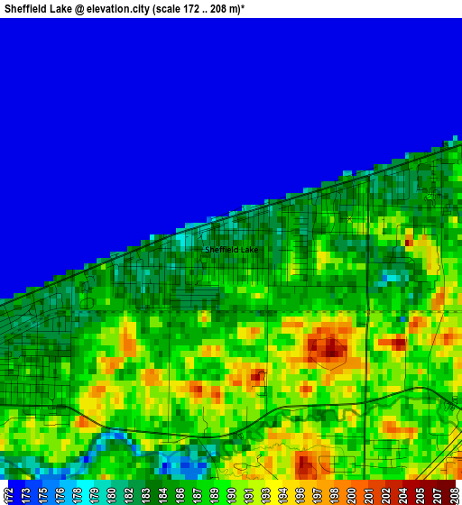
Below is the Elevation map of Sheffield Lake, which displays elevation range with different colors. Scale of the first map is from 172 to 208 m (564 to 682 ft) with average elevation of 181.3 meters (=595 ft) [note 1]
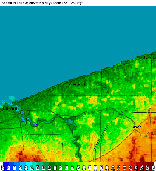
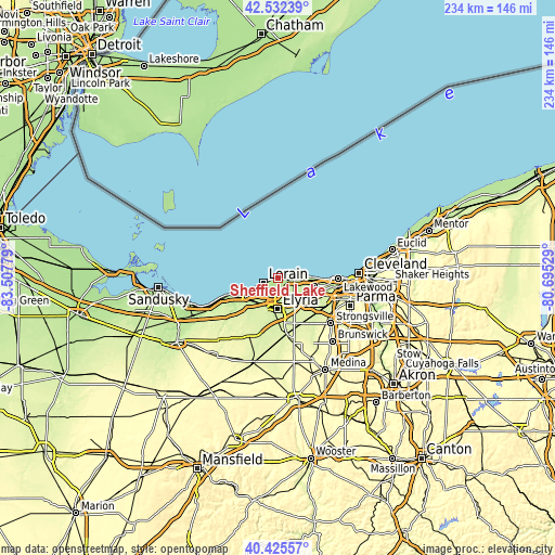
These maps also provides idea of topography and contour of this city, they are displayed at different zoom levels. More info about maps, scale and edge coordinates you can find below images.
| \ | Map #1 | Map #2 | Topo.Map |
| Scale [m] | 172..208 m | 157..230 m | × |
| Scale [ft] | 564..682 ft | 515..755 ft | × |
| Average | 181.3 m = 595 ft | 183.7 m = 603 ft | × |
| Width | 7.32 km = 4.5 mi | 14.64 km = 9.1 mi | 234.3 km = 145.6 mi |
| Height | 7.32 km = 4.5 mi | 14.64 km = 9.1 mi | 234.2 km = 145.5 mi |
| ↑Max Latitude | 41.520451° | 41.553345° | 42.53239° |
| Latitude at center | 41.48754° | 41.48754° | 41.48754° |
| ↓Min Latitude | 41.454612° | 41.421668° | 40.42557° |
| ← Min Longitude | -82.145485° | -82.189431° | -83.50779° |
| Longitude center | -82.10154° | -82.10154° | -82.10154° |
| →Max Longitude | -82.057595° | -82.013649° | -80.69529° |
Nearby cities:
Cities around Sheffield Lake sort by population:
• Lorain elevation 187 m
7.8 km,  240°
240°
• Elyria 222 m
13.3 km,  182°
182°
• North Ridgeville 222 m
12.9 km,  147°
147°
• Westlake 225 m
15.7 km,  103°
103°
• North Olmsted 231 m
16.9 km,  118°
118°
• Avon Lake 188 m
6.4 km,  72°
72°
• Avon 201 m
6.8 km,  125°
125°
• Avon Center 209 m
7.5 km,  114°
114°
• Bay Village 192 m
15 km,  91°
91°
• Amherst 212 m
14.2 km,  225°
225°
• Sheffield 188 m
2.8 km, 175°
• Sheffield 200 m
7.4 km, 176°
Multilingual:
 En español:
Sheffield Lake elevación 187 m.
 En France:
Sheffield Lake élévation 187 m.
 Auf Deutsch:
Sheffield Lake höhe über dem Meeresspiegel ist 187 m.

Sources and notes:
- [note 1] Map square and city borders are not equal. Map elevation data is calculated only from area inside that square.
- [src 1] Elevation data from geonames database provided with same terms of usage.
- [src 2] The elevation map of Sheffield Lake is generated using elevation data from NASA's 3 arcsec (90m) resolution SRTM data.
- [src 3] Base (background) map © OpenStreetMap contributors tiles are generated by Geofabrik and OpenTopoMap.
Copyright & License:
This Sheffield Lake Elevation Map is licensed under CC BY-SA. You may reuse any part from this page, if you give a proper credit by linking to this URL:
 More info on terms of use page.