Norton elevation
Norton (Ohio, Summit County), United States elevation is 322 meters and Norton elevation in feet is 1056 ft above sea level [src 1]. Norton is a populated place (feature code) with elevation that is 43 meters (141 ft) bigger than average city elevation in United States.
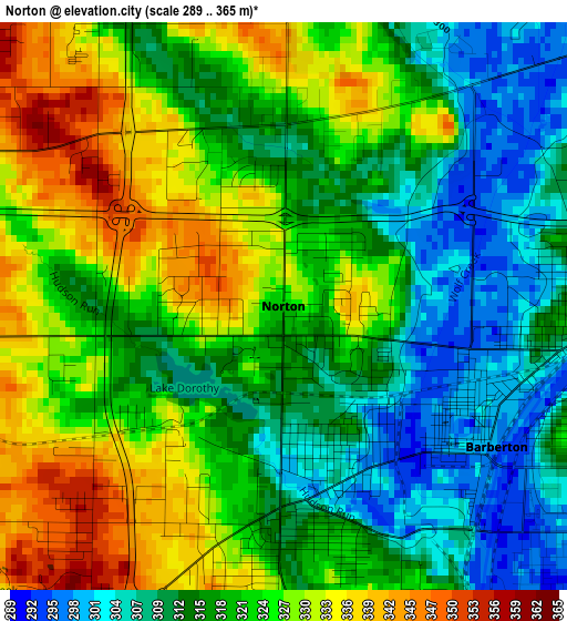
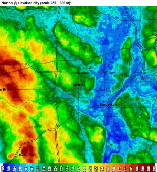
Below is the Elevation map of Norton, which displays elevation range with different colors. Scale of the first map is from 289 to 365 m (948 to 1198 ft) with average elevation of 320.2 meters (=1051 ft) [note 1]
These maps also provides idea of topography and contour of this city, they are displayed at different zoom levels. More info about maps, scale and edge coordinates you can find below images.
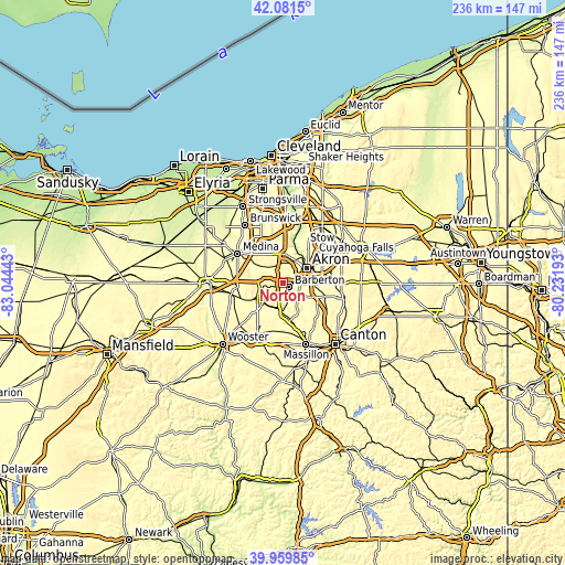
| \ | Map #1 | Map #2 | Topo.Map |
| Scale [m] | 289..365 m | 285..399 m | × |
| Scale [ft] | 948..1198 ft | 935..1309 ft | × |
| Average | 320.2 m = 1051 ft | 326.6 m = 1072 ft | × |
| Width | 7.37 km = 4.6 mi | 14.74 km = 9.2 mi | 235.9 km = 146.6 mi |
| Height | 7.37 km = 4.6 mi | 14.74 km = 9.2 mi | 235.9 km = 146.6 mi |
| ↑Max Latitude | 41.062363° | 41.095489° | 42.0815° |
| Latitude at center | 41.02922° | 41.02922° | 41.02922° |
| ↓Min Latitude | 40.99606° | 40.962884° | 39.95985° |
| ← Min Longitude | -81.682125° | -81.726071° | -83.04443° |
| Longitude center | -81.63818° | -81.63818° | -81.63818° |
| →Max Longitude | -81.594235° | -81.550289° | -80.23193° |
Nearby cities:
Cities around Norton sort by population:
• Akron elevation 295 m
11.6 km,  59°
59°
• Barberton 292 m
3.3 km,  123°
123°
• Wadsworth 357 m
7.7 km,  267°
267°
• New Franklin 334 m
12.7 km,  140°
140°
• Copley 319 m
7.8 km,  356°
356°
• Fairlawn 309 m
11.2 km,  12°
12°
• Portage Lakes 330 m
9.6 km,  104°
104°
• Rittman 297 m
13.3 km,  244°
244°
• Montrose-Ghent 317 m
13.9 km, 358°
• Doylestown 381 m
8.2 km,  216°
216°
• Manchester 332 m
11.8 km,  150°
150°
• Clinton 291 m
11.4 km,  176°
176°
Multilingual:
 En español:
Norton elevación 322 m.
 En France:
Norton élévation 322 m.


Sources and notes:
- [note 1] Map square and city borders are not equal. Map elevation data is calculated only from area inside that square.
- [src 1] Elevation data from geonames database provided with same terms of usage.
- [src 2] The elevation map of Norton is generated using elevation data from NASA's 3 arcsec (90m) resolution SRTM data.
- [src 3] Base (background) map © OpenStreetMap contributors tiles are generated by Geofabrik and OpenTopoMap.
Copyright & License:
This Norton Elevation Map is licensed under CC BY-SA. You may reuse any part from this page, if you give a proper credit by linking to this URL:
 More info on terms of use page.