McComb elevation
McComb (Ohio, Hancock County), United States elevation is 236 meters and McComb elevation in feet is 774 ft above sea level [src 1]. McComb is a populated place (feature code) with elevation that is 43 meters (141 ft) smaller than average city elevation in United States.
Below is the Elevation map of McComb, which displays elevation range with different colors. Scale of the first map is from 217 to 259 m (712 to 850 ft) with average elevation of 231.1 meters (=758 ft) [note 1]
These maps also provides idea of topography and contour of this city, they are displayed at different zoom levels. More info about maps, scale and edge coordinates you can find below images.
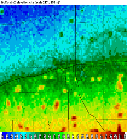
| \ | Map #1 | Topo.Map |
| Scale [m] | 217..259 m | × |
| Scale [ft] | 712..850 ft | × |
| Average | 231.1 m = 758 ft | × |
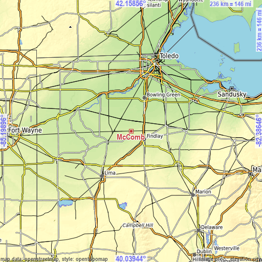
| Width | 7.36 km = 4.6 mi | 235.6 km = 146.4 mi |
| Height | 7.36 km = 4.6 mi | 235.6 km = 146.4 mi |
| ↑Max Latitude | 41.140653° | 42.15856° |
| Latitude at center | 41.10755° | 41.10755° |
| ↓Min Latitude | 41.07443° | 40.03944° |
| ← Min Longitude | -83.836655° | -85.19896° |
| Longitude center | -83.79271° | -83.79271° |
| →Max Longitude | -83.748765° | -82.38646° |
Nearby cities:
Cities around McComb sort by population:
• Findlay elevation 238 m
13.9 km,  120°
120°
• Bowling Green 213 m
32 km,  21°
21°
• Ottawa 222 m
23.5 km,  245°
245°
• Bluffton 258 m
24.9 km,  198°
198°
• North Baltimore 222 m
12.7 km,  48°
48°
• Columbus Grove 237 m
30.5 km,  226°
226°
• Leipsic 234 m
16.1 km,  266°
266°
• Deshler 216 m
14.2 km,  321°
321°
• Weston 207 m
26.4 km,  359°
359°
• Arlington 265 m
26.6 km,  153°
153°
• Pandora 236 m
22.7 km,  218°
218°
• Glandorf 222 m
25.6 km, 249°
Multilingual:
 En español:
McComb elevación 236 m.
 En France:
McComb élévation 236 m.


Sources and notes:
- [note 1] Map square and city borders are not equal. Map elevation data is calculated only from area inside that square.
- [src 1] Elevation data from geonames database provided with same terms of usage.
- [src 2] The elevation map of McComb is generated using elevation data from NASA's 3 arcsec (90m) resolution SRTM data.
- [src 3] Base (background) map © OpenStreetMap contributors tiles are generated by Geofabrik and OpenTopoMap.
Copyright & License:
This McComb Elevation Map is licensed under CC BY-SA. You may reuse any part from this page, if you give a proper credit by linking to this URL:
 More info on terms of use page.