East Liverpool elevation
East Liverpool (Ohio, Columbiana County), United States elevation is 235 meters and East Liverpool elevation in feet is 771 ft above sea level [src 1]. East Liverpool is a populated place (feature code) with elevation that is 44 meters (144 ft) smaller than average city elevation in United States.
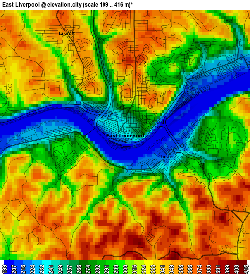
Below is the Elevation map of East Liverpool, which displays elevation range with different colors. Scale of the first map is from 199 to 416 m (653 to 1365 ft) with average elevation of 312.1 meters (=1024 ft) [note 1]
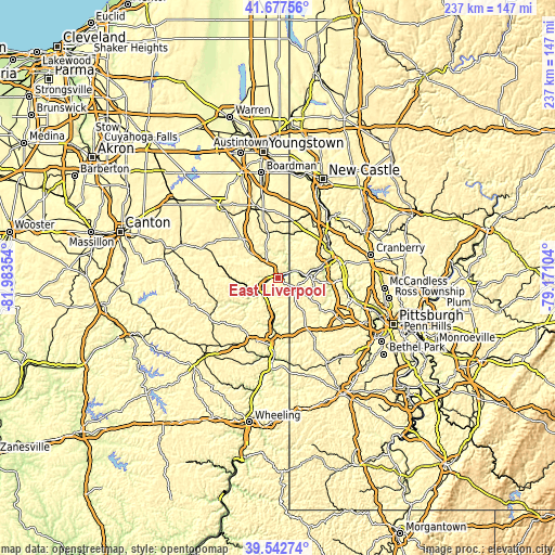
These maps also provides idea of topography and contour of this city, they are displayed at different zoom levels. More info about maps, scale and edge coordinates you can find below images.
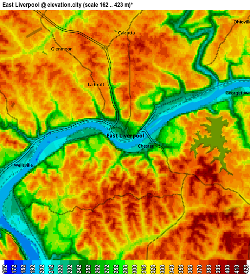
| \ | Map #1 | Map #2 | Topo.Map |
| Scale [m] | 199..416 m | 162..423 m | × |
| Scale [ft] | 653..1365 ft | 531..1388 ft | × |
| Average | 312.1 m = 1024 ft | 322.4 m = 1058 ft | × |
| Width | 7.42 km = 4.6 mi | 14.84 km = 9.2 mi | 237.4 km = 147.5 mi |
| Height | 7.42 km = 4.6 mi | 14.84 km = 9.2 mi | 237.4 km = 147.5 mi |
| ↑Max Latitude | 40.652029° | 40.685361° | 41.67756° |
| Latitude at center | 40.61868° | 40.61868° | 40.61868° |
| ↓Min Latitude | 40.585315° | 40.551933° | 39.54274° |
| ← Min Longitude | -80.621235° | -80.665181° | -81.98354° |
| Longitude center | -80.57729° | -80.57729° | -80.57729° |
| →Max Longitude | -80.533345° | -80.489399° | -79.17104° |
Nearby cities:
Cities around East Liverpool sort by population:
• Toronto elevation 212 m
17.3 km,  186°
186°
• Calcutta 339 m
6.1 km,  0°
0°
• Ohioville 339 m
9.7 km,  45°
45°
• Wellsville 215 m
6.3 km,  253°
253°
• Midland 240 m
11.1 km,  82°
82°
• Chester 216 m
1.4 km,  116°
116°
• Glenmoor 346 m
6.5 km,  323°
323°
• Industry 212 m
13.9 km, 78°
• Newell 231 m
2.3 km,  269°
269°
• Salineville 279 m
22 km, 271°
• La Croft 355 m
3.5 km,  330°
330°
• New Cumberland 213 m
13.8 km, 190°
Multilingual:
 En español:
East Liverpool elevación 235 m.
 En France:
East Liverpool élévation 235 m.
 Auf Deutsch:
East Liverpool höhe über dem Meeresspiegel ist 235 m.

Sources and notes:
- [note 1] Map square and city borders are not equal. Map elevation data is calculated only from area inside that square.
- [src 1] Elevation data from geonames database provided with same terms of usage.
- [src 2] The elevation map of East Liverpool is generated using elevation data from NASA's 3 arcsec (90m) resolution SRTM data.
- [src 3] Base (background) map © OpenStreetMap contributors tiles are generated by Geofabrik and OpenTopoMap.
Copyright & License:
This East Liverpool Elevation Map is licensed under CC BY-SA. You may reuse any part from this page, if you give a proper credit by linking to this URL:
 More info on terms of use page.