Continental elevation
Continental (Ohio, Putnam County), United States elevation is 219 meters and Continental elevation in feet is 719 ft above sea level [src 1]. Continental is a populated place (feature code) with elevation that is 60 meters (197 ft) smaller than average city elevation in United States.
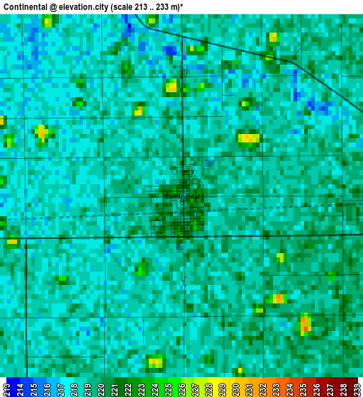
Below is the Elevation map of Continental, which displays elevation range with different colors. Scale of the first map is from 213 to 233 m (699 to 764 ft) with average elevation of 218.4 meters (=717 ft) [note 1]
These maps also provides idea of topography and contour of this city, they are displayed at different zoom levels. More info about maps, scale and edge coordinates you can find below images.
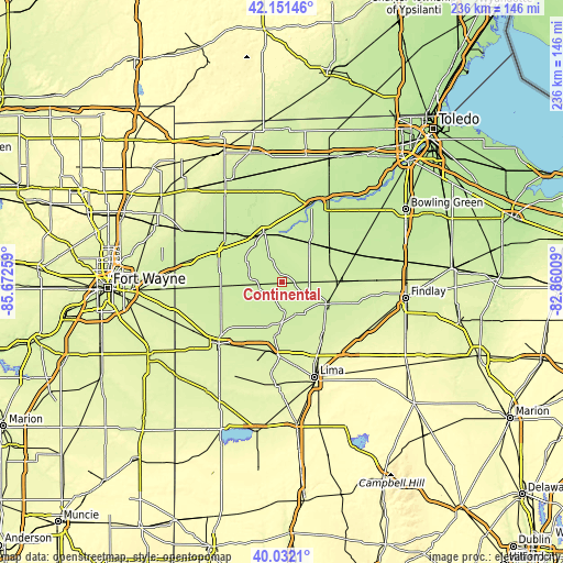
| \ | Map #1 | Topo.Map |
| Scale [m] | 213..233 m | × |
| Scale [ft] | 699..764 ft | × |
| Average | 218.4 m = 717 ft | × |
| Width | 7.36 km = 4.6 mi | 235.7 km = 146.5 mi |
| Height | 7.36 km = 4.6 mi | 235.6 km = 146.4 mi |
| ↑Max Latitude | 41.133437° | 42.15146° |
| Latitude at center | 41.10033° | 41.10033° |
| ↓Min Latitude | 41.067206° | 40.0321° |
| ← Min Longitude | -84.310285° | -85.67259° |
| Longitude center | -84.26634° | -84.26634° |
| →Max Longitude | -84.222395° | -82.86009° |
Nearby cities:
Cities around Continental sort by population:
• Defiance elevation 206 m
21.8 km,  339°
339°
• Napoleon 208 m
34.5 km,  19°
19°
• Delphos 235 m
29.3 km,  192°
192°
• Ottawa 222 m
20.5 km,  116°
116°
• Paulding 221 m
26.6 km,  279°
279°
• Columbus Grove 237 m
26.7 km,  138°
138°
• Leipsic 234 m
23.6 km,  90°
90°
• Deshler 216 m
33 km,  68°
68°
• Kalida 220 m
14.2 km,  156°
156°
• Pandora 236 m
30.7 km, 123°
• Holgate 218 m
19.9 km,  34°
34°
• Glandorf 222 m
17.6 km, 116°
Multilingual:
 En español:
Continental elevación 219 m.
 En France:
Continental élévation 219 m.
 Auf Deutsch:
Continental höhe über dem Meeresspiegel ist 219 m.

Sources and notes:
- [note 1] Map square and city borders are not equal. Map elevation data is calculated only from area inside that square.
- [src 1] Elevation data from geonames database provided with same terms of usage.
- [src 2] The elevation map of Continental is generated using elevation data from NASA's 3 arcsec (90m) resolution SRTM data.
- [src 3] Base (background) map © OpenStreetMap contributors tiles are generated by Geofabrik and OpenTopoMap.
Copyright & License:
This Continental Elevation Map is licensed under CC BY-SA. You may reuse any part from this page, if you give a proper credit by linking to this URL:
 More info on terms of use page.