Watertown elevation
Watertown (New York, Jefferson County), United States elevation is 146 meters and Watertown elevation in feet is 479 ft above sea level [src 1]. Watertown is a seat of a second-order administrative division (feature code) with elevation that is 133 meters (436 ft) smaller than average city elevation in United States.
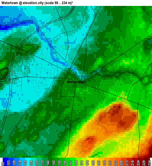
Below is the Elevation map of Watertown, which displays elevation range with different colors. Scale of the first map is from 98 to 234 m (322 to 768 ft) with average elevation of 146.7 meters (=481 ft) [note 1]
These maps also provides idea of topography and contour of this city, they are displayed at different zoom levels. More info about maps, scale and edge coordinates you can find below images.
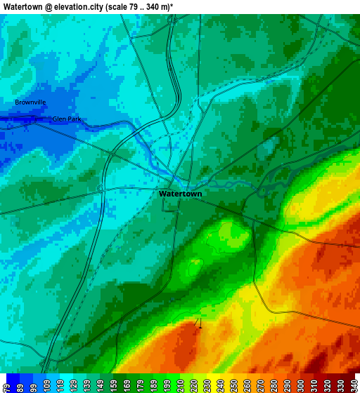
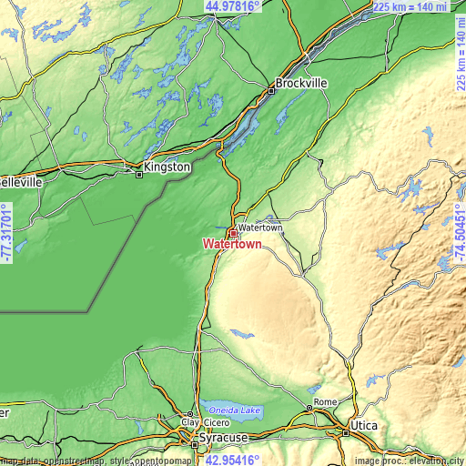
| \ | Map #1 | Map #2 | Topo.Map |
| Scale [m] | 98..234 m | 79..340 m | × |
| Scale [ft] | 322..768 ft | 259..1115 ft | × |
| Average | 146.7 m = 481 ft | 166.8 m = 547 ft | × |
| Width | 7.03 km = 4.4 mi | 14.07 km = 8.7 mi | 225 km = 139.8 mi |
| Height | 7.03 km = 4.4 mi | 14.07 km = 8.7 mi | 225 km = 139.8 mi |
| ↑Max Latitude | 44.006397° | 44.037996° | 44.97816° |
| Latitude at center | 43.97478° | 43.97478° | 43.97478° |
| ↓Min Latitude | 43.943147° | 43.911496° | 42.95416° |
| ← Min Longitude | -75.954705° | -75.998651° | -77.31701° |
| Longitude center | -75.91076° | -75.91076° | -75.91076° |
| →Max Longitude | -75.866815° | -75.822869° | -74.50451° |
Nearby cities:
Cities around Watertown sort by population:
• Fort Drum elevation 160 m
15.1 km,  51°
51°
• Carthage 234 m
24.1 km,  89°
89°
• Calcium 144 m
7.4 km,  44°
44°
• West Carthage 236 m
23.7 km, 90°
• Clayton 83 m
32.6 km,  334°
334°
• Adams 186 m
20.5 km,  206°
206°
• Adams Center 194 m
14.8 km, 210°
• Sackets Harbor 89 m
17 km,  259°
259°
• Black River 173 m
10.2 km,  65°
65°
• Philadelphia 150 m
25.7 km, 38°
• Brownville 107 m
6.9 km,  301°
301°
• Dexter 86 m
11.3 km,  288°
288°
Multilingual:
 En español:
Watertown elevación 146 m.
 En France:
Watertown élévation 146 m.
 Auf Deutsch:
Watertown höhe über dem Meeresspiegel ist 146 m.

Sources and notes:
- [note 1] Map square and city borders are not equal. Map elevation data is calculated only from area inside that square.
- [src 1] Elevation data from geonames database provided with same terms of usage.
- [src 2] The elevation map of Watertown is generated using elevation data from NASA's 3 arcsec (90m) resolution SRTM data.
- [src 3] Base (background) map © OpenStreetMap contributors tiles are generated by Geofabrik and OpenTopoMap.
Copyright & License:
This Watertown Elevation Map is licensed under CC BY-SA. You may reuse any part from this page, if you give a proper credit by linking to this URL:
 More info on terms of use page.