Valhalla elevation
Valhalla (New York, Westchester County), United States elevation is 86 meters and Valhalla elevation in feet is 282 ft above sea level [src 1]. Valhalla is a populated place (feature code) with elevation that is 193 meters (633 ft) smaller than average city elevation in United States.
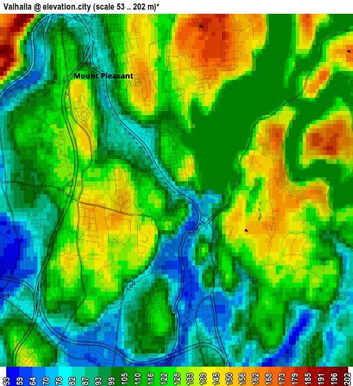
Below is the Elevation map of Valhalla, which displays elevation range with different colors. Scale of the first map is from 53 to 202 m (174 to 663 ft) with average elevation of 113.6 meters (=373 ft) [note 1]
These maps also provides idea of topography and contour of this city, they are displayed at different zoom levels. More info about maps, scale and edge coordinates you can find below images.
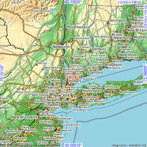
| \ | Map #1 | Topo.Map |
| Scale [m] | 53..202 m | × |
| Scale [ft] | 174..663 ft | × |
| Average | 113.6 m = 373 ft | × |
| Width | 7.37 km = 4.6 mi | 235.7 km = 146.5 mi |
| Height | 7.37 km = 4.6 mi | 235.7 km = 146.5 mi |
| ↑Max Latitude | 41.10794° | 42.12636° |
| Latitude at center | 41.07482° | 41.07482° |
| ↓Min Latitude | 41.041683° | 40.00618° |
| ← Min Longitude | -73.819075° | -75.18138° |
| Longitude center | -73.77513° | -73.77513° |
| →Max Longitude | -73.731185° | -72.36888° |
Nearby cities:
Cities around Valhalla sort by population:
• Greenburgh elevation 63 m
7.4 km,  230°
230°
• White Plains 82 m
4.7 km,  167°
167°
• Tarrytown 45 m
7 km,  271°
271°
• Sleepy Hollow 34 m
7.1 km,  279°
279°
• Pleasantville 94 m
6.6 km,  347°
347°
• Hartsdale 59 m
6.5 km,  197°
197°
• Elmsford 58 m
4.4 km,  239°
239°
• Purchase 110 m
6.3 km,  126°
126°
• Hawthorne 89 m
4 km,  334°
334°
• Armonk 125 m
7.7 km,  41°
41°
• Thornwood 90 m
5.4 km,  356°
356°
• Fairview 63 m
4 km,  208°
208°
Multilingual:
 En español:
Valhalla elevación 86 m.
 En France:
Valhalla élévation 86 m.


Sources and notes:
- [note 1] Map square and city borders are not equal. Map elevation data is calculated only from area inside that square.
- [src 1] Elevation data from geonames database provided with same terms of usage.
- [src 2] The elevation map of Valhalla is generated using elevation data from NASA's 3 arcsec (90m) resolution SRTM data.
- [src 3] Base (background) map © OpenStreetMap contributors tiles are generated by Geofabrik and OpenTopoMap.
Copyright & License:
This Valhalla Elevation Map is licensed under CC BY-SA. You may reuse any part from this page, if you give a proper credit by linking to this URL:
 More info on terms of use page.