Troy elevation
Troy (New York, Rensselaer County), United States elevation is 17 meters and Troy elevation in feet is 56 ft above sea level [src 1]. Troy is a seat of a second-order administrative division (feature code) with elevation that is 262 meters (860 ft) smaller than average city elevation in United States.
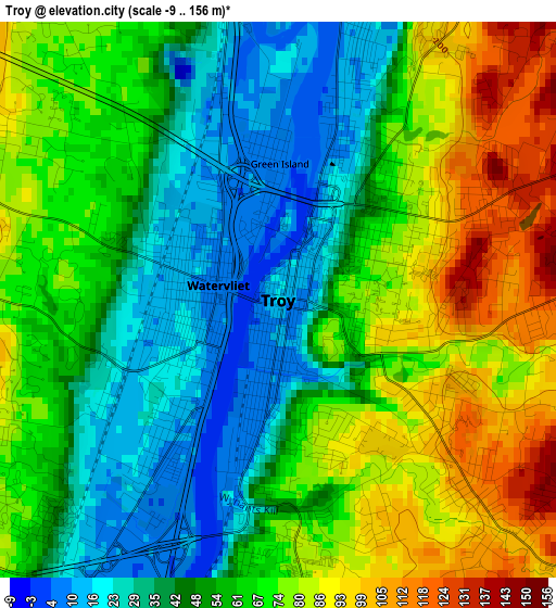
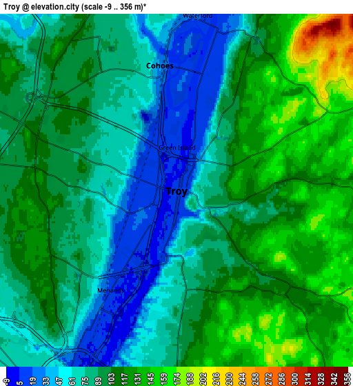
Below is the Elevation map of Troy, which displays elevation range with different colors. Scale of the first map is from -9 to 156 m (-30 to 512 ft) with average elevation of 59.3 meters (=195 ft) [note 1]
These maps also provides idea of topography and contour of this city, they are displayed at different zoom levels. More info about maps, scale and edge coordinates you can find below images.
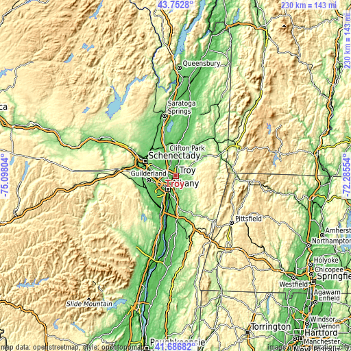
| \ | Map #1 | Map #2 | Topo.Map |
| Scale [m] | -9..156 m | -9..356 m | × |
| Scale [ft] | -30..512 ft | -30..1168 ft | × |
| Average | 59.3 m = 195 ft | 95 m = 312 ft | × |
| Width | 7.18 km = 4.5 mi | 14.36 km = 8.9 mi | 229.7 km = 142.7 mi |
| Height | 7.18 km = 4.5 mi | 14.36 km = 8.9 mi | 229.7 km = 142.7 mi |
| ↑Max Latitude | 42.760683° | 42.792939° | 43.7528° |
| Latitude at center | 42.72841° | 42.72841° | 42.72841° |
| ↓Min Latitude | 42.69612° | 42.663814° | 41.68682° |
| ← Min Longitude | -73.735735° | -73.779681° | -75.09804° |
| Longitude center | -73.69179° | -73.69179° | -73.69179° |
| →Max Longitude | -73.647845° | -73.603899° | -72.28554° |
Nearby cities:
Cities around Troy sort by population:
• Albany elevation 50 m
9.9 km,  211°
211°
• West Albany 59 m
8.7 km,  234°
234°
• Latham 110 m
5.9 km,  290°
290°
• Cohoes 32 m
5.1 km,  352°
352°
• Roessleville 77 m
10.1 km,  248°
248°
• Watervliet 7 m
0.8 km,  283°
283°
• Rensselaer 5 m
10.4 km,  203°
203°
• Menands 11 m
4.9 km, 213°
• Wynantskill 105 m
5.2 km,  132°
132°
• Green Island 9 m
1.8 km,  0°
0°
• Waterford 24 m
7.2 km,  6°
6°
• Poestenkill 149 m
11.2 km,  112°
112°
Multilingual:
 En español:
Troy elevación 17 m.
 En France:
Troy élévation 17 m.


Sources and notes:
- [note 1] Map square and city borders are not equal. Map elevation data is calculated only from area inside that square.
- [src 1] Elevation data from geonames database provided with same terms of usage.
- [src 2] The elevation map of Troy is generated using elevation data from NASA's 3 arcsec (90m) resolution SRTM data.
- [src 3] Base (background) map © OpenStreetMap contributors tiles are generated by Geofabrik and OpenTopoMap.
Copyright & License:
This Troy Elevation Map is licensed under CC BY-SA. You may reuse any part from this page, if you give a proper credit by linking to this URL:
 More info on terms of use page.