Town Line elevation
Town Line (New York, Erie County), United States elevation is 230 meters and Town Line elevation in feet is 755 ft above sea level [src 1]. Town Line is a populated place (feature code) with elevation that is 49 meters (161 ft) smaller than average city elevation in United States.
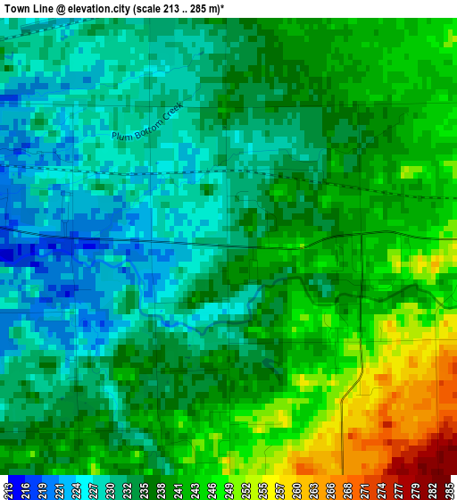
Below is the Elevation map of Town Line, which displays elevation range with different colors. Scale of the first map is from 213 to 285 m (699 to 935 ft) with average elevation of 236.8 meters (=777 ft) [note 1]
These maps also provides idea of topography and contour of this city, they are displayed at different zoom levels. More info about maps, scale and edge coordinates you can find below images.
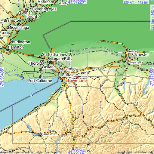
| \ | Map #1 | Topo.Map |
| Scale [m] | 213..285 m | × |
| Scale [ft] | 699..935 ft | × |
| Average | 236.8 m = 777 ft | × |
| Width | 7.16 km = 4.4 mi | 229.1 km = 142.4 mi |
| Height | 7.16 km = 4.4 mi | 229.1 km = 142.4 mi |
| ↑Max Latitude | 42.922798° | 43.91229° |
| Latitude at center | 42.89061° | 42.89061° |
| ↓Min Latitude | 42.858405° | 41.85172° |
| ← Min Longitude | -78.621745° | -79.98405° |
| Longitude center | -78.5778° | -78.5778° |
| →Max Longitude | -78.533855° | -77.17155° |
Nearby cities:
Cities around Town Line sort by population:
• Cheektowaga elevation 198 m
14.5 km,  275°
275°
• Depew 207 m
9.4 km, 279°
• Lancaster 206 m
7.6 km, 278°
• East Aurora 281 m
14 km,  191°
191°
• Harris Hill 222 m
11.6 km,  315°
315°
• Williamsville 209 m
15.4 km,  302°
302°
• Akron 229 m
16 km,  24°
24°
• Clarence 230 m
9.6 km,  353°
353°
• Alden 267 m
7.1 km,  81°
81°
• Elma Center 247 m
8.3 km,  215°
215°
• Clarence Center 197 m
14.2 km,  339°
339°
• Billington Heights 297 m
12.5 km,  198°
198°
Multilingual:
 En español:
Town Line elevación 230 m.
 En France:
Town Line élévation 230 m.
 Auf Deutsch:
Town Line höhe über dem Meeresspiegel ist 230 m.

Sources and notes:
- [note 1] Map square and city borders are not equal. Map elevation data is calculated only from area inside that square.
- [src 1] Elevation data from geonames database provided with same terms of usage.
- [src 2] The elevation map of Town Line is generated using elevation data from NASA's 3 arcsec (90m) resolution SRTM data.
- [src 3] Base (background) map © OpenStreetMap contributors tiles are generated by Geofabrik and OpenTopoMap.
Copyright & License:
This Town Line Elevation Map is licensed under CC BY-SA. You may reuse any part from this page, if you give a proper credit by linking to this URL:
 More info on terms of use page.