Schoharie elevation
Schoharie (New York, Schoharie County), United States elevation is 188 meters and Schoharie elevation in feet is 617 ft above sea level [src 1]. Schoharie is a seat of a second-order administrative division (feature code) with elevation that is 91 meters (299 ft) smaller than average city elevation in United States.
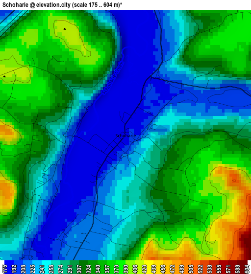
Below is the Elevation map of Schoharie, which displays elevation range with different colors. Scale of the first map is from 175 to 604 m (574 to 1982 ft) with average elevation of 293.7 meters (=964 ft) [note 1]
These maps also provides idea of topography and contour of this city, they are displayed at different zoom levels. More info about maps, scale and edge coordinates you can find below images.
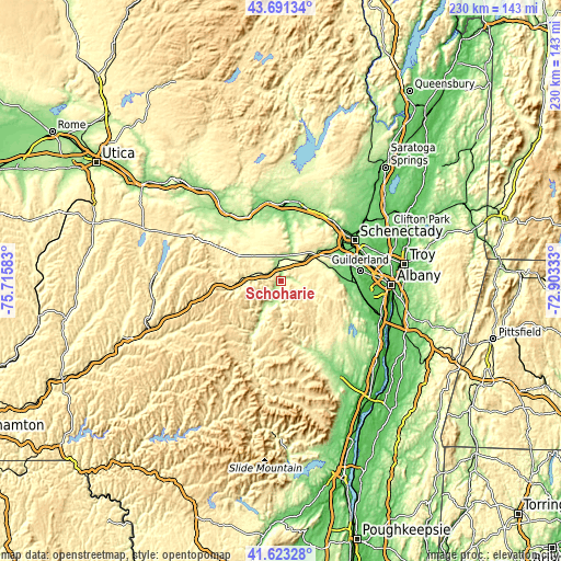
| \ | Map #1 | Topo.Map |
| Scale [m] | 175..604 m | × |
| Scale [ft] | 574..1982 ft | × |
| Average | 293.7 m = 964 ft | × |
| Width | 7.19 km = 4.5 mi | 229.9 km = 142.9 mi |
| Height | 7.19 km = 4.5 mi | 229.9 km = 142.9 mi |
| ↑Max Latitude | 42.698215° | 43.69134° |
| Latitude at center | 42.66591° | 42.66591° |
| ↓Min Latitude | 42.633588° | 41.62328° |
| ← Min Longitude | -74.353525° | -75.71583° |
| Longitude center | -74.30958° | -74.30958° |
| →Max Longitude | -74.265635° | -72.90333° |
Nearby cities:
Cities around Schoharie sort by population:
• Rotterdam elevation 101 m
30.8 km,  64°
64°
• Amsterdam 110 m
31.9 km,  18°
18°
• Scotia 77 m
33.4 km, 57°
• Wellsville 118 m
23.5 km,  7°
7°
• Cobleskill 280 m
14.4 km,  275°
275°
• Voorheesville 101 m
31.2 km,  92°
92°
• Durham 237 m
31.7 km,  159°
159°
• Canajoharie 96 m
34.2 km,  321°
321°
• Altamont 141 m
22.9 km,  80°
80°
• Middleburgh 197 m
7.7 km,  194°
194°
• Tribes Hill 130 m
32.2 km,  3°
3°
• Fonda 90 m
32.6 km,  350°
350°
Multilingual:
 En español:
Schoharie elevación 188 m.
 En France:
Schoharie élévation 188 m.
 Auf Deutsch:
Schoharie höhe über dem Meeresspiegel ist 188 m.

Sources and notes:
- [note 1] Map square and city borders are not equal. Map elevation data is calculated only from area inside that square.
- [src 1] Elevation data from geonames database provided with same terms of usage.
- [src 2] The elevation map of Schoharie is generated using elevation data from NASA's 3 arcsec (90m) resolution SRTM data.
- [src 3] Base (background) map © OpenStreetMap contributors tiles are generated by Geofabrik and OpenTopoMap.
Copyright & License:
This Schoharie Elevation Map is licensed under CC BY-SA. You may reuse any part from this page, if you give a proper credit by linking to this URL:
 More info on terms of use page.