Rouses Point elevation
Rouses Point (New York, Clinton County), United States elevation is 35 meters and Rouses Point elevation in feet is 115 ft above sea level [src 1]. Rouses Point is a populated place (feature code) with elevation that is 244 meters (801 ft) smaller than average city elevation in United States.
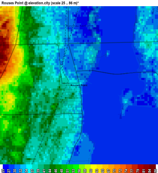
Below is the Elevation map of Rouses Point, which displays elevation range with different colors. Scale of the first map is from 25 to 86 m (82 to 282 ft) with average elevation of 36.7 meters (=120 ft) [note 1]
These maps also provides idea of topography and contour of this city, they are displayed at different zoom levels. More info about maps, scale and edge coordinates you can find below images.
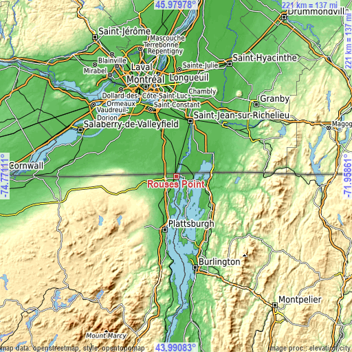
| \ | Map #1 | Topo.Map |
| Scale [m] | 25..86 m | × |
| Scale [ft] | 82..282 ft | × |
| Average | 36.7 m = 120 ft | × |
| Width | 6.91 km = 4.3 mi | 221.2 km = 137.4 mi |
| Height | 6.91 km = 4.3 mi | 221.1 km = 137.4 mi |
| ↑Max Latitude | 45.024999° | 45.97978° |
| Latitude at center | 44.99393° | 44.99393° |
| ↓Min Latitude | 44.962844° | 43.99083° |
| ← Min Longitude | -73.408805° | -74.77111° |
| Longitude center | -73.36486° | -73.36486° |
| →Max Longitude | -73.320915° | -71.95861° |
Nearby cities:
Cities around Rouses Point sort by population:
• Plattsburgh elevation 45 m
33.5 km,  191°
191°
• Saint Albans 127 m
30.1 km,  132°
132°
• Dannemora 434 m
41.5 km,  223°
223°
• Swanton 45 m
20.7 km,  114°
114°
• Milton 93 m
44.2 km,  152°
152°
• Cumberland Head 44 m
31 km, 185°
• Peru 99 m
47.9 km,  195°
195°
• Morrisonville 108 m
36.9 km, 204°
• Plattsburgh West 98 m
36.2 km, 197°
• Enosburg Falls 129 m
45 km,  102°
102°
• Champlain 31 m
6.5 km,  262°
262°
• North Hero 33 m
19.5 km,  158°
158°
Multilingual:
 En español:
Rouses Point elevación 35 m.
 En France:
Rouses Point élévation 35 m.
 Auf Deutsch:
Rouses Point höhe über dem Meeresspiegel ist 35 m.

Sources and notes:
- [note 1] Map square and city borders are not equal. Map elevation data is calculated only from area inside that square.
- [src 1] Elevation data from geonames database provided with same terms of usage.
- [src 2] The elevation map of Rouses Point is generated using elevation data from NASA's 3 arcsec (90m) resolution SRTM data.
- [src 3] Base (background) map © OpenStreetMap contributors tiles are generated by Geofabrik and OpenTopoMap.
Copyright & License:
This Rouses Point Elevation Map is licensed under CC BY-SA. You may reuse any part from this page, if you give a proper credit by linking to this URL:
 More info on terms of use page.