Ronkonkoma elevation
Ronkonkoma (New York, Suffolk County), United States elevation is 37 meters and Ronkonkoma elevation in feet is 121 ft above sea level [src 1]. Ronkonkoma is a populated place (feature code) with elevation that is 242 meters (794 ft) smaller than average city elevation in United States.
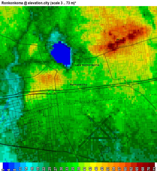
Below is the Elevation map of Ronkonkoma, which displays elevation range with different colors. Scale of the first map is from 3 to 73 m (10 to 240 ft) with average elevation of 33.4 meters (=110 ft) [note 1]
These maps also provides idea of topography and contour of this city, they are displayed at different zoom levels. More info about maps, scale and edge coordinates you can find below images.
| \ | Map #1 | Map #2 | Topo.Map |
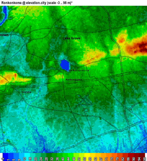
| Scale [m] | 3..73 m | -3..98 m | × |
| Scale [ft] | 10..240 ft | -10..322 ft | × |
| Average | 33.4 m = 110 ft | 29.9 m = 98 ft | × |
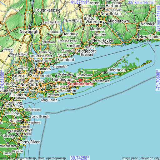
| Width | 7.4 km = 4.6 mi | 14.79 km = 9.2 mi | 236.7 km = 147.1 mi |
| Height | 7.4 km = 4.6 mi | 14.79 km = 9.2 mi | 236.7 km = 147.1 mi |
| ↑Max Latitude | 40.84863° | 40.881864° | 41.87111° |
| Latitude at center | 40.81538° | 40.81538° | 40.81538° |
| ↓Min Latitude | 40.782113° | 40.748829° | 39.74258° |
| ← Min Longitude | -73.156275° | -73.200221° | -74.51858° |
| Longitude center | -73.11233° | -73.11233° | -73.11233° |
| →Max Longitude | -73.068385° | -73.024439° | -71.70608° |
Nearby cities:
Cities around Ronkonkoma sort by population:
• Central Islip elevation 28 m
8 km,  249°
249°
• Centereach 32 m
4.9 km,  12°
12°
• Holbrook 39 m
2.9 km,  96°
96°
• Hauppauge 23 m
7.7 km,  278°
278°
• Lake Ronkonkoma 26 m
2.7 km,  324°
324°
• Holtsville 35 m
5.7 km,  90°
90°
• Farmingville 32 m
7.2 km,  75°
75°
• Nesconset 41 m
5.4 km, 319°
• Lake Grove 39 m
4.2 km,  356°
356°
• Bohemia 22 m
5.1 km,  182°
182°
• Islandia 21 m
4.9 km,  255°
255°
• Village of the Branch 22 m
7.8 km,  305°
305°
Multilingual:
 En español:
Ronkonkoma elevación 37 m.
 En France:
Ronkonkoma élévation 37 m.
 Auf Deutsch:
Ronkonkoma höhe über dem Meeresspiegel ist 37 m.

Sources and notes:
- [note 1] Map square and city borders are not equal. Map elevation data is calculated only from area inside that square.
- [src 1] Elevation data from geonames database provided with same terms of usage.
- [src 2] The elevation map of Ronkonkoma is generated using elevation data from NASA's 3 arcsec (90m) resolution SRTM data.
- [src 3] Base (background) map © OpenStreetMap contributors tiles are generated by Geofabrik and OpenTopoMap.
Copyright & License:
This Ronkonkoma Elevation Map is licensed under CC BY-SA. You may reuse any part from this page, if you give a proper credit by linking to this URL:
 More info on terms of use page.