Richland elevation
Richland (New York, Oswego County), United States elevation is 172 meters and Richland elevation in feet is 564 ft above sea level [src 1]. Richland is a populated place (feature code) with elevation that is 107 meters (351 ft) smaller than average city elevation in United States.
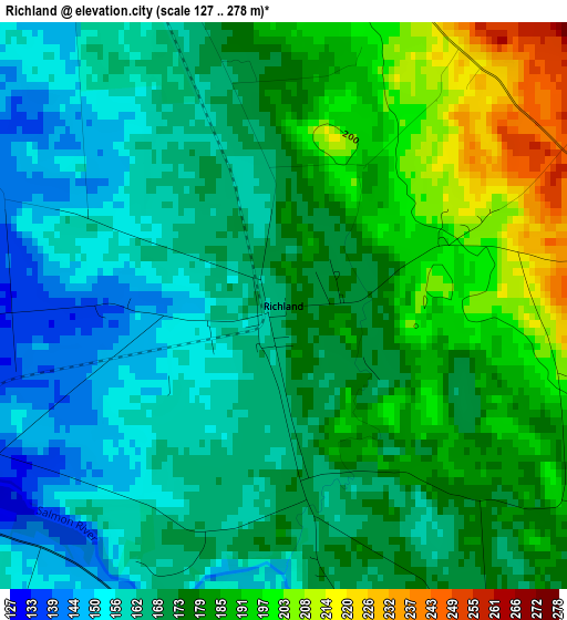
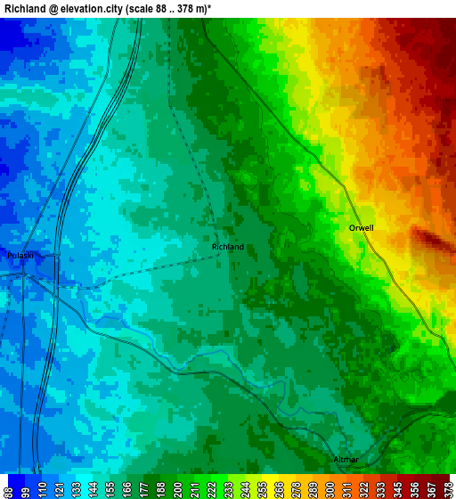
Below is the Elevation map of Richland, which displays elevation range with different colors. Scale of the first map is from 127 to 278 m (417 to 912 ft) with average elevation of 173.8 meters (=570 ft) [note 1]
These maps also provides idea of topography and contour of this city, they are displayed at different zoom levels. More info about maps, scale and edge coordinates you can find below images.
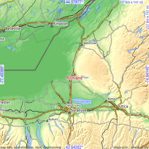
| \ | Map #1 | Map #2 | Topo.Map |
| Scale [m] | 127..278 m | 88..378 m | × |
| Scale [ft] | 417..912 ft | 289..1240 ft | × |
| Average | 173.8 m = 570 ft | 186.8 m = 613 ft | × |
| Width | 7.08 km = 4.4 mi | 14.16 km = 8.8 mi | 226.6 km = 140.8 mi |
| Height | 7.08 km = 4.4 mi | 14.16 km = 8.8 mi | 226.6 km = 140.8 mi |
| ↑Max Latitude | 43.601342° | 43.633156° | 44.57977° |
| Latitude at center | 43.56951° | 43.56951° | 43.56951° |
| ↓Min Latitude | 43.537662° | 43.505796° | 42.54202° |
| ← Min Longitude | -76.091645° | -76.135591° | -77.45395° |
| Longitude center | -76.0477° | -76.0477° | -76.0477° |
| →Max Longitude | -76.003755° | -75.959809° | -74.64145° |
Nearby cities:
Cities around Richland sort by population:
• Oswego elevation 95 m
39.4 km,  251°
251°
• Fulton 107 m
40.5 km,  227°
227°
• Volney 137 m
35.5 km,  224°
224°
• Brewerton 119 m
37.6 km,  191°
191°
• Pulaski 112 m
6.5 km,  267°
267°
• Camden 158 m
35.6 km,  137°
137°
• Adams 186 m
26.7 km,  4°
4°
• Central Square 138 m
32.4 km, 194°
• Mexico 128 m
19 km, 230°
• Adams Center 194 m
32.5 km,  5°
5°
• Constantia 118 m
36 km,  173°
173°
• Minetto 104 m
39.6 km,  241°
241°
Multilingual:
 En español:
Richland elevación 172 m.
 En France:
Richland élévation 172 m.
 Auf Deutsch:
Richland höhe über dem Meeresspiegel ist 172 m.

Sources and notes:
- [note 1] Map square and city borders are not equal. Map elevation data is calculated only from area inside that square.
- [src 1] Elevation data from geonames database provided with same terms of usage.
- [src 2] The elevation map of Richland is generated using elevation data from NASA's 3 arcsec (90m) resolution SRTM data.
- [src 3] Base (background) map © OpenStreetMap contributors tiles are generated by Geofabrik and OpenTopoMap.
Copyright & License:
This Richland Elevation Map is licensed under CC BY-SA. You may reuse any part from this page, if you give a proper credit by linking to this URL:
 More info on terms of use page.