Randolph elevation
Randolph (New York, Cattaraugus County), United States elevation is 391 meters and Randolph elevation in feet is 1283 ft above sea level [src 1]. Randolph is a populated place (feature code) with elevation that is 112 meters (367 ft) bigger than average city elevation in United States.
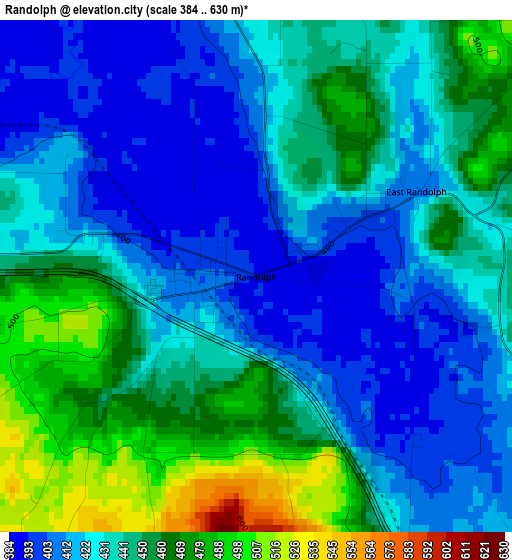
Below is the Elevation map of Randolph, which displays elevation range with different colors. Scale of the first map is from 384 to 630 m (1260 to 2067 ft) with average elevation of 436.6 meters (=1432 ft) [note 1]
These maps also provides idea of topography and contour of this city, they are displayed at different zoom levels. More info about maps, scale and edge coordinates you can find below images.
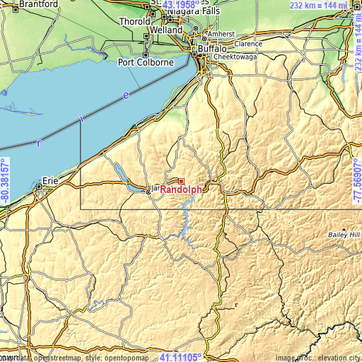
| \ | Map #1 | Topo.Map |
| Scale [m] | 384..630 m | × |
| Scale [ft] | 1260..2067 ft | × |
| Average | 436.6 m = 1432 ft | × |
| Width | 7.24 km = 4.5 mi | 231.8 km = 144 mi |
| Height | 7.24 km = 4.5 mi | 231.8 km = 144 mi |
| ↑Max Latitude | 42.194576° | 43.1958° |
| Latitude at center | 42.16201° | 42.16201° |
| ↓Min Latitude | 42.129427° | 41.11105° |
| ← Min Longitude | -79.019265° | -80.38157° |
| Longitude center | -78.97532° | -78.97532° |
| →Max Longitude | -78.931375° | -77.56907° |
Nearby cities:
Cities around Randolph sort by population:
• Jamestown elevation 420 m
22.6 km,  251°
251°
• Salamanca 417 m
21.5 km,  91°
91°
• Lakewood 409 m
30.2 km,  257°
257°
• Gowanda 235 m
33.6 km,  5°
5°
• Jamestown West 458 m
26.5 km, 252°
• Falconer 387 m
19 km, 255°
• North Warren 372 m
35.2 km,  204°
204°
• Frewsburg 398 m
19.2 km,  231°
231°
• Russell 383 m
27.8 km,  208°
208°
• Kiantone 465 m
24.1 km, 229°
• Little Valley 489 m
17.2 km,  54°
54°
• Celoron 407 m
26 km, 257°
Multilingual:
 En español:
Randolph elevación 391 m.
 En France:
Randolph élévation 391 m.
 Auf Deutsch:
Randolph höhe über dem Meeresspiegel ist 391 m.

Sources and notes:
- [note 1] Map square and city borders are not equal. Map elevation data is calculated only from area inside that square.
- [src 1] Elevation data from geonames database provided with same terms of usage.
- [src 2] The elevation map of Randolph is generated using elevation data from NASA's 3 arcsec (90m) resolution SRTM data.
- [src 3] Base (background) map © OpenStreetMap contributors tiles are generated by Geofabrik and OpenTopoMap.
Copyright & License:
This Randolph Elevation Map is licensed under CC BY-SA. You may reuse any part from this page, if you give a proper credit by linking to this URL:
 More info on terms of use page.