Pawling elevation
Pawling (New York, Dutchess County), United States elevation is 138 meters and Pawling elevation in feet is 453 ft above sea level [src 1]. Pawling is a populated place (feature code) with elevation that is 141 meters (463 ft) smaller than average city elevation in United States.
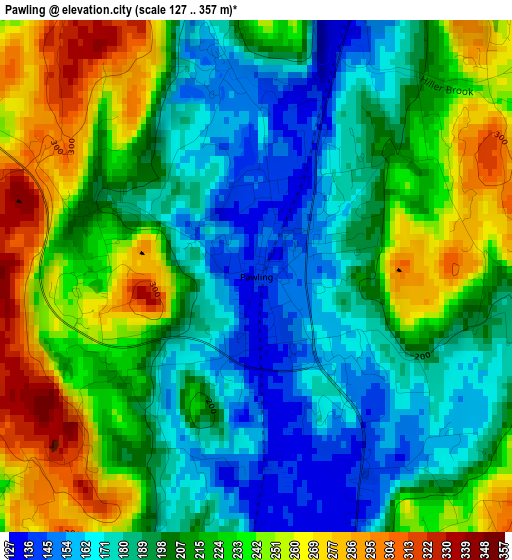
Below is the Elevation map of Pawling, which displays elevation range with different colors. Scale of the first map is from 127 to 357 m (417 to 1171 ft) with average elevation of 210.6 meters (=691 ft) [note 1]
These maps also provides idea of topography and contour of this city, they are displayed at different zoom levels. More info about maps, scale and edge coordinates you can find below images.
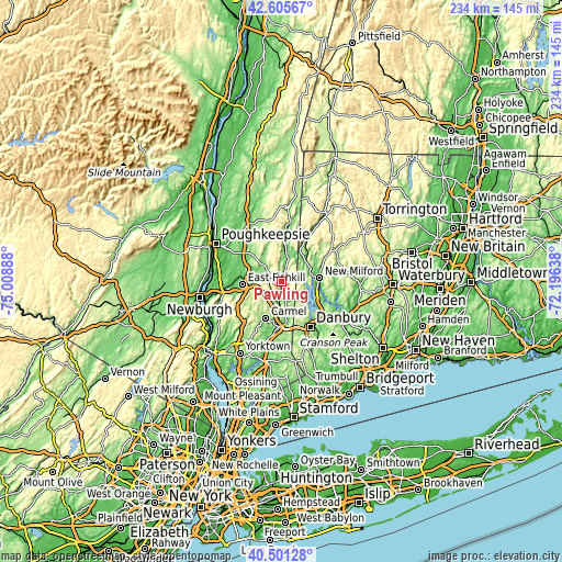
| \ | Map #1 | Topo.Map |
| Scale [m] | 127..357 m | × |
| Scale [ft] | 417..1171 ft | × |
| Average | 210.6 m = 691 ft | × |
| Width | 7.31 km = 4.5 mi | 234 km = 145.4 mi |
| Height | 7.31 km = 4.5 mi | 234 km = 145.4 mi |
| ↑Max Latitude | 41.594913° | 42.60567° |
| Latitude at center | 41.56204° | 41.56204° |
| ↓Min Latitude | 41.52915° | 40.50128° |
| ← Min Longitude | -73.646575° | -75.00888° |
| Longitude center | -73.60263° | -73.60263° |
| →Max Longitude | -73.558685° | -72.19638° |
Nearby cities:
Cities around Pawling sort by population:
• New Fairfield elevation 181 m
14.4 km,  137°
137°
• Lake Carmel 243 m
12.5 km,  206°
206°
• Carmel Hamlet 159 m
17.8 km,  202°
202°
• New Milford 73 m
16.2 km,  84°
84°
• Carmel 175 m
16 km, 203°
• Putnam Lake 159 m
12.1 km,  157°
157°
• Sherman 146 m
9.1 km, 77°
• Kent 123 m
20.9 km,  29°
29°
• Brewster 150 m
18.4 km,  183°
183°
• Brewster Hill 192 m
15.4 km, 180°
• Dover Plains 124 m
20 km,  6°
6°
• Hillside Lake 114 m
17.3 km,  289°
289°
Multilingual:
 En español:
Pawling elevación 138 m.
 En France:
Pawling élévation 138 m.


Sources and notes:
- [note 1] Map square and city borders are not equal. Map elevation data is calculated only from area inside that square.
- [src 1] Elevation data from geonames database provided with same terms of usage.
- [src 2] The elevation map of Pawling is generated using elevation data from NASA's 3 arcsec (90m) resolution SRTM data.
- [src 3] Base (background) map © OpenStreetMap contributors tiles are generated by Geofabrik and OpenTopoMap.
Copyright & License:
This Pawling Elevation Map is licensed under CC BY-SA. You may reuse any part from this page, if you give a proper credit by linking to this URL:
 More info on terms of use page.