Oneonta elevation
Oneonta (New York, Otsego County), United States elevation is 343 meters and Oneonta elevation in feet is 1125 ft above sea level [src 1]. Oneonta is a populated place (feature code) with elevation that is 64 meters (210 ft) bigger than average city elevation in United States.
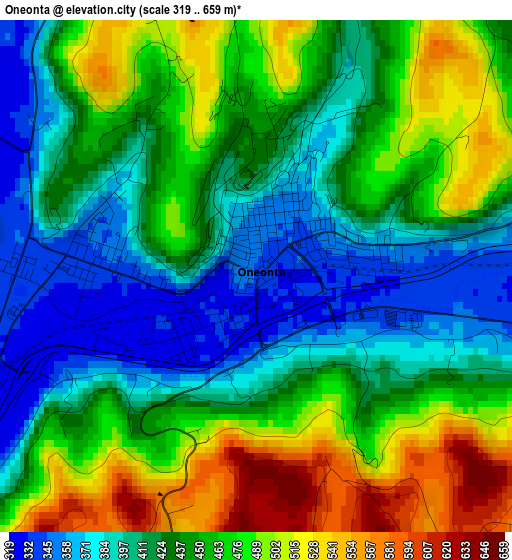
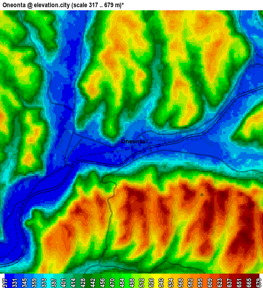
Below is the Elevation map of Oneonta, which displays elevation range with different colors. Scale of the first map is from 319 to 659 m (1047 to 2162 ft) with average elevation of 441.9 meters (=1450 ft) [note 1]
These maps also provides idea of topography and contour of this city, they are displayed at different zoom levels. More info about maps, scale and edge coordinates you can find below images.
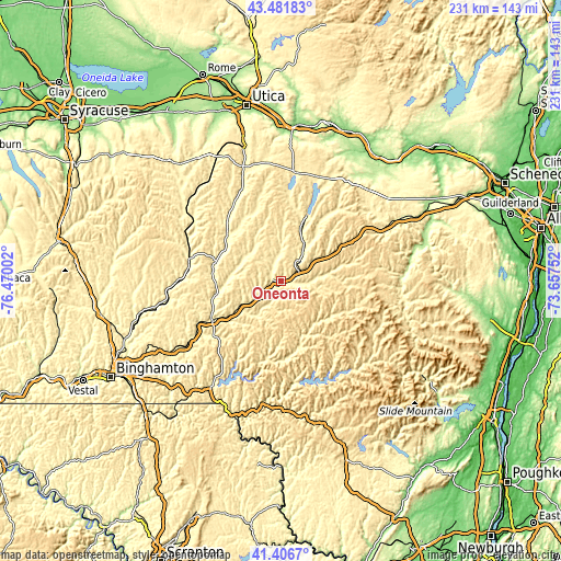
| \ | Map #1 | Map #2 | Topo.Map |
| Scale [m] | 319..659 m | 317..679 m | × |
| Scale [ft] | 1047..2162 ft | 1040..2228 ft | × |
| Average | 441.9 m = 1450 ft | 462.6 m = 1518 ft | × |
| Width | 7.21 km = 4.5 mi | 14.42 km = 9 mi | 230.7 km = 143.4 mi |
| Height | 7.21 km = 4.5 mi | 14.42 km = 9 mi | 230.7 km = 143.4 mi |
| ↑Max Latitude | 42.485276° | 42.517675° | 43.48183° |
| Latitude at center | 42.45286° | 42.45286° | 42.45286° |
| ↓Min Latitude | 42.420427° | 42.387978° | 41.4067° |
| ← Min Longitude | -75.107715° | -75.151661° | -76.47002° |
| Longitude center | -75.06377° | -75.06377° | -75.06377° |
| →Max Longitude | -75.019825° | -74.975879° | -73.65752° |
Nearby cities:
Cities around Oneonta sort by population:
• Norwich elevation 310 m
38.7 km,  283°
283°
• Sidney 303 m
31 km,  240°
240°
• Delhi 420 m
22.9 km,  147°
147°
• Walton 373 m
32 km,  189°
189°
• West End 448 m
3 km,  305°
305°
• Cooperstown 377 m
29.8 km,  22°
22°
• Oxford 298 m
43.8 km,  268°
268°
• Sherburne 322 m
43.5 km, 305°
• Bainbridge 305 m
38.5 km, 242°
• Worcester 407 m
29.9 km,  59°
59°
• Unadilla 313 m
24.9 km, 235°
• Stamford 556 m
37.2 km,  97°
97°
Multilingual:
 En español:
Oneonta elevación 343 m.
 En France:
Oneonta élévation 343 m.


Sources and notes:
- [note 1] Map square and city borders are not equal. Map elevation data is calculated only from area inside that square.
- [src 1] Elevation data from geonames database provided with same terms of usage.
- [src 2] The elevation map of Oneonta is generated using elevation data from NASA's 3 arcsec (90m) resolution SRTM data.
- [src 3] Base (background) map © OpenStreetMap contributors tiles are generated by Geofabrik and OpenTopoMap.
Copyright & License:
This Oneonta Elevation Map is licensed under CC BY-SA. You may reuse any part from this page, if you give a proper credit by linking to this URL:
 More info on terms of use page.