Marion elevation
Marion (New York, Wayne County), United States elevation is 140 meters and Marion elevation in feet is 459 ft above sea level [src 1]. Marion is a populated place (feature code) with elevation that is 139 meters (456 ft) smaller than average city elevation in United States.
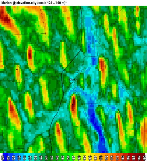
Below is the Elevation map of Marion, which displays elevation range with different colors. Scale of the first map is from 124 to 190 m (407 to 623 ft) with average elevation of 148.3 meters (=487 ft) [note 1]
These maps also provides idea of topography and contour of this city, they are displayed at different zoom levels. More info about maps, scale and edge coordinates you can find below images.
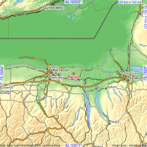
| \ | Map #1 | Topo.Map |
| Scale [m] | 124..190 m | × |
| Scale [ft] | 407..623 ft | × |
| Average | 148.3 m = 487 ft | × |
| Width | 7.13 km = 4.4 mi | 228.2 km = 141.8 mi |
| Height | 7.13 km = 4.4 mi | 228.2 km = 141.8 mi |
| ↑Max Latitude | 43.175456° | 44.16085° |
| Latitude at center | 43.1434° | 43.1434° |
| ↓Min Latitude | 43.111327° | 42.10873° |
| ← Min Longitude | -77.233095° | -78.5954° |
| Longitude center | -77.18915° | -77.18915° |
| →Max Longitude | -77.145205° | -75.7829° |
Nearby cities:
Cities around Marion sort by population:
• Newark elevation 136 m
13.2 km,  144°
144°
• Webster 134 m
21 km,  291°
291°
• Fairport 152 m
21.1 km,  256°
256°
• Lyons 125 m
18.4 km,  118°
118°
• Palmyra 151 m
9.5 km,  202°
202°
• Williamson 134 m
9 km,  1°
1°
• Ontario 134 m
11.5 km,  318°
318°
• Clifton Springs 180 m
20.6 km,  168°
168°
• Sodus 135 m
14.8 km,  44°
44°
• Manchester 182 m
19.6 km,  189°
189°
• Macedon 143 m
12.1 km,  227°
227°
• Shortsville 191 m
21 km, 187°
Multilingual:
 En español:
Marion elevación 140 m.
 En France:
Marion élévation 140 m.


Sources and notes:
- [note 1] Map square and city borders are not equal. Map elevation data is calculated only from area inside that square.
- [src 1] Elevation data from geonames database provided with same terms of usage.
- [src 2] The elevation map of Marion is generated using elevation data from NASA's 3 arcsec (90m) resolution SRTM data.
- [src 3] Base (background) map © OpenStreetMap contributors tiles are generated by Geofabrik and OpenTopoMap.
Copyright & License:
This Marion Elevation Map is licensed under CC BY-SA. You may reuse any part from this page, if you give a proper credit by linking to this URL:
 More info on terms of use page.